- Remove Small landforms filter Small landforms
- Remove Cultural landscapes filter Cultural landscapes
- Remove Ulvik filter Ulvik
- Remove Kvam filter Kvam
- Remove Voss, frå 2020 del av nye Voss herad. filter Voss, frå 2020 del av nye Voss herad.
- Remove Sediments filter Sediments
- Remove Øygarden, frå 2020 del av nye Øygarden kommune. filter Øygarden, frå 2020 del av nye Øygarden kommune.
- Remove Road constructions filter Road constructions

Osa
At the bottom of the Osa fjord there is a cultural landscape marked by great contrasts; the wide terraces and the river delta at the fjord contrast with the steep hillsides in the background, where Norddalen leads up to the mountain. There are two farms here. Osa and Sævartveit – the farm at the river mouth and the hollow by the sea.

Bolstad
The village at Bolstadøyri acquired its structure around the middle of the 1800s, but from the old days there has been a meeting place here; court location and trading post. The guesthouse place stems from the second half of the 17th century, and in the previous century Bolstadøyri was one of the largest rural trading posts in Nordhordland.

Stalheimskleiva
From the oldest times on record in Norway one of the most important traffic arteries between west and east Norway has passed across Bolstad – Voss – Stalheim – Gudvangen and Lærdal. The post road between Oslo and Bergen was established here 1647, but in Stalheimskleiva there was only a packhorse track right up to the 1840s. Wheeled transport and carts were in little use in the mountains in West Norway up to that time.

Botnen
Fyksesundet and Botnagrenda present a fine experience of the landscape and cultural history; a geographically isolated local settlement with extensive cultural contact with the outside world.

Nes
The farm Nes lies directly inside Mundheim on a forested headland in the fjord between Mundheimsvika and Bondesundet, a farm with an attractive and well-kept cultural landscape.

Jomfrunuten
Freezing and thawing are processes that influence plant cover, move enormous blocks, stretche long mounds of earth, break open bedrock and create patterns in stone and earth.

Rallarvegen
They rest there, all as one, the silent witnesses of Western Norway's saga of creation: Precambrian basement, phyllite and thrust sheet. In the end came the glaciers and sculptured the vast landscape. Along the ground or on the horizon, from bicycle or on foot - the landscape tells its story - and it tells it clearer on Rallarvegen than many other places.

Ulvik-village
The ice cap that covered the land during each of the 40 past ice ages over the past 2 million years of Earth's history pressed down the crust of the earth - like a finger on a rubber ball. And when the ice finally loosened its grip 11,000 years ago, the earth's crust rose again, most where the ice was thickest, least where it was thin, quickly in the beginning, and later more slowly. To this day, the land in the inner part of Norway continues to rise by perhaps one millimetre per year. By and large, however, the crust in Hordaland has again reached equilibrium after the weight of the ice was removed.
Tjeldstømarka
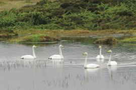
There is no place in Hordaland where there are so many over-wintering song swans as in Tjeldstømarka. And there are few places in the county that have had this birdfowl as a guest for as long.

Bordalsgjelet
Deep down between the stone polished phyllite bedrock in Bordalsgjelet canyon, there is a cascading river. In close cooperation with hard polishing stones, the water has carved into the bedrock for thousands of years - and is still doing so today.

