- Remove Small landforms filter Small landforms
- Remove Middle age filter Middle age
- Remove Eidfjord filter Eidfjord
- Remove Road constructions filter Road constructions
- Remove Trading posts and guesthouses filter Trading posts and guesthouses
- Remove Farm sites filter Farm sites
- Remove Lakes, rivers and river networks filter Lakes, rivers and river networks
- Remove Os, frå 2020 del av nye Bjørnafjorden kommune filter Os, frå 2020 del av nye Bjørnafjorden kommune

Agastølen
Whoever wanders the mountain plateau will form time to time hit upon old mountain summer farms, with solid old stone sheds, half sunk into the ground; a building tradition that has roots into prehistoric times. When we have been satiated with untouched Nature, it is somewhat comforting to come upon the old mountain chalets - they represent a type of human encroachment that we not only accept, but appreciate. They arouse a feeling of recognition and are a distinct witness to how people in the rural communities have made use of even the most remote resources.

Halne
At Halnefjorden, a few hundred metres east of Halne mountain lodge, lie the remains of two stone sheds – Halnelægeret. Some generations ago the cattle drovers stopped here in the summer; they were the cowboys of their time. But Halnelægeret already had a long history before the cattle drovers came.

Heggjagarden
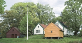
The transport exchange on the farm Vik in Eidfjord was an important part of the communication network in older times. This is where people secured transport by boat out in the fjord, those travelling across the mountain from east and down into Måbødalen. The transport exchange was situated at “Wiige grund”. Today the highway cuts through the farmyard; the main farmhouse from the 1800s lies on the upper side of the road, the large sea-house, with a bakery in former times, lies close to the fjord.

Hjølmo
In the steep hillside in Hjølmodalen, a small side valley from Øvre Eidfjord (Upper Eidfjord), which has been a key entrance to the Hardanger Plateau, the hamlet of old farmhouses still lie clustered together. The yard is empty today, some of the houses are used in the summer, but the grass grows round all the corners.

Kjeåsen
High up above the fjord, at a height of 600m lie the two holdings at Kjeåsen. Today you can drive there by car, through a new tunnel that the power engineers in Sima have drilled. Until 1974 the only road went up the steep hillside, along iron bolted ladders across dizzying rocks – a road for the strong at heart.

Krækkjavassdraget
Few other animal species on Hardangervidda have been as much the focus of scientific research as the spotted trout. The spotted trout is considered to be a genetic variant of brown trout. It lives in parts of the Krækkjav water system. Otherwise, on a world scale, this species is only found in a small area in Kaukasus, and possibly also in a lake in Rondane.

Måbø
Måbø is the uppermost farm in Måbødalen. This narrow and steep mountain valley has been one of the routes from the fjord communities up to the mountain plateau from times immemorial. We are not certain of the meaning of the name Måbø. Perhaps it has its origin in an Old Norse male name Mávi, from the name for seagull, már. The last syllable “bø” means farm. Today Måbø gives us a compact close-up of the subsistence economy: the small farm with the clearance piles, stone walls and a lane that guided the animals into the yard, at the foot of the great mountain expanse.


Simadalen
On the 10th of August, 1937, over half of the agricultural land in Simadalen was submerged by the river. The damage to roads and houses was also catastrophic. This was the most destructive flood ever recorded in Hordaland.
Ferstad
Ferstad is well worth a visit. The farm lies on a little hillock south of Lekven: a beautiful official residence from the 1700s.

