- Remove Small landforms filter Small landforms
- Remove Maritime environments filter Maritime environments
- Remove Seabirds filter Seabirds
- Remove Monastery filter Monastery
- Remove Fitjar filter Fitjar
- Remove Middle age filter Middle age
- Remove Large landforms filter Large landforms
- Remove Sediments filter Sediments
- Remove Etne filter Etne
- Remove Askøy filter Askøy

Herdla farm
Numerous finds show that the settlement at Herdla goes back to prehistoric times, and the large estate at Herdla has enjoyed a central place in the nation’s history since High Middle Ages. As Ask, Herdla was part of the country estate Harald Hårfagre took over as he took command of the west of Norway.

Støle church
The stone church at Støle may have been built around 1160 probably as a private chapel for the mighty Stødle clan. It is likely that it was Erling Skakke, the king’s representative and father of king Magnus Erlingsson, who built the church.

Herdla – glacial deposits
The shift in the landscape is striking between the barren craggy moors north on Askøy and the green fields of Herdla, which has the county's biggest farm. The majority of Herdla, such as the island appears today, is a gift from the glacier: The glacier that advanced here over 12,000 years ago stopped at the northern tip of Askøy and took its time building up the moraine on Herdla. Since then, Herdla has been under continual transformation. The re-organisation of the loose sediment deposits continues today.
Herdleflaket
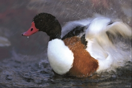
Spring, summer and autumn, there is bird life on Valen, and the tidal zone is especially attractive. Out on Herdlaflaket, you see ducks and other diving birds all year round, but most in winter.

The village of Etne
Much of the sand and gravel that the town of Etne is built on was laid down at the end of the Ice Age and is evidence of melting glaciers and roaring meltwater rivers. The uncompacted material in the big terraces leave their unmistakeable mark on the wide elongated valleys.


Fitjarøyane
If we study the group of islands south of Selbjørns Fjord from the air or on a sea map, we will notice that many of the islands are elongated and lie systematically in rows. The islands are divided by long sounds, for example Trollosen, Nuleia and Hjelmosen, which are oriented in a south-southeast to north-northwesterly direction.

Fitjar- potatoes
The deep agricultural soils in Fitjar are found especially in the area between Lake Storavatnet and Breivika. The many stonewalls in the area reflect that the earth probably was full of stones and stone blocks. The stones that couldn't be dug out had also a function: they stored heat that helped to grow potatoes.


