- Remove Small landforms filter Small landforms
- Remove Maritime environments filter Maritime environments
- Remove Seabirds filter Seabirds
- Remove Monastery filter Monastery
- Remove Fitjar filter Fitjar
- Remove Ullensvang, frå 2020 del av nye Ullensvang kommune. filter Ullensvang, frå 2020 del av nye Ullensvang kommune.
- Remove Austrheim filter Austrheim
- Remove Samnanger filter Samnanger
- Remove Austevoll filter Austevoll
- Remove Lakes, rivers and river networks filter Lakes, rivers and river networks

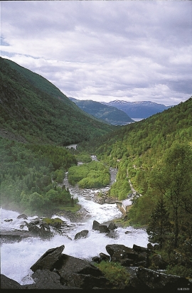
Fossen Bratte
The steep drop by Fossen cliff has been the biggest challenge for those who wished to make a road over Kvamskogen through the years. Leave the car by the monument on the old road and take a walk down to the bend by the waterfall that Bergen-folk call "The bridal veil". Why is there a waterfall just here?

Frøland
Much rain, a steep drop and nearness to Bergen meant that the power-making potential of the Samnanger water system was exploited early. Samnanger was thus one of the first power-producing municipalities in western Norway. With its subsequent expansion and new power stations, about 400 gigawatts of electricity per hour were produced on average each year. This is enough to meet the energy needs of 25,000 households.


Notaholmen
The fishnet shed at Notaholmen stands as a reminder of the days when people used to row out on the fjord to set their nets. On Notaholmen the nets were dried, repaired and tanned. And it was a great advantage to store them in a place inaccessible for rats and mice.


Krossøy
Furthest north in the island community Rongevær, at the entrance to Fensfjorden, lies Krossøy. Belonging to the farm are the islands of Krossøy, Husøy, Kårøy, Lyngkjerringa, Søre Kjerringa, Rotøy and Kuhovet. All of them have been inhabited. On Krossøy itself today there are four holdings. The marine use environment here is one of the best preserved along the West Norwegian coast.