- Remove Small landforms filter Small landforms
- Remove Maritime environments filter Maritime environments
- Remove People and Society filter People and Society
- Remove Defense filter Defense
- Remove Place filter Place
- Remove Settlements, Villages, Towns filter Settlements, Villages, Towns
- Remove Urban environments filter Urban environments
- Remove Chieftains and royal lines filter Chieftains and royal lines

Bru
Bruosen is one of the few river harbours in the county. As landing place for the churchgoers, this place and the boatshed environment follow a tradition that goes back to the Middle Ages, but the country store of today is much younger.
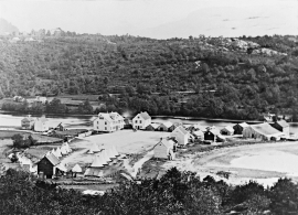
Osøyro
The coastal settlement of Os begins to take form in the middle of the 1800s. This is when craftsmen and traders begin to settle at the river delta.

Notaholmen
The fishnet shed at Notaholmen stands as a reminder of the days when people used to row out on the fjord to set their nets. On Notaholmen the nets were dried, repaired and tanned. And it was a great advantage to store them in a place inaccessible for rats and mice.

Bryggen
In the 1300s Bergen was a trading centre of European dimension. The town is thought to have had around 7000 inhabitants and was the largest and most important in the country. In a European context it was an average size town. At this time the most tightly built town area was still mostly east of Vågen from Holmen in the north to Vågsbotn in the south. Already in medieval times, latest in the 1340s, this area was called Bryggen.

Vågsbunnen
Vågsbotn was the name of the innermost part of the eastern part of town from Auta-almenning (today’s Vetrlidsalmenning), skirting the bottom of Vågen to Allehelgenskirken (All Saints’ Church) (at the present Allehelgensgate). In early medieval times Vågen reached almost all the way to Olavskirken (the Cathedral). It was a relatively wide bay inside the premonitory where Korskirken was built. The area was therefore much shorter than what is known as Vågsbunnen today.

Strandsiden
During the 1300s Strandsiden changed from a rural area with a monastery to a pulsating trading centre with boathouses, storehouses and embankment.
Ramsøy
“At thick of night a thundering knock on the door; the man in the house wakes up, jumps out and demands: Who cries? Yes, now you must out, the beacon shines on Høgenut. And in the same breath, every man knew that strife had hit the land.”

Golta- Long house
In the years between the wars a major registration of houses and house costumes, house construction methods, fireplaces and forms of housing clusters was started in West Norway – an ambitious mapping of everything that came under the name “Registration of Culture and Geography in West Norway”. One of the places of which material was gathered in 1938 was an old multi-room house at Golta; new and interesting material for the researchers from the Historical Museum, but well known within the local building tradition through several generations.

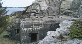
Tælavåg
Tælavåg has a significant place in the history of the German occupation in WWII. The small community by the sea, where for centuries people had made a living from farming and fishing in harmony with the natural resources, in 1942 became the victim of German reprisals without their equal in Norwegian war history. The collection of war histories in Tælavåg provides us with a close-up of the dramatic events.

Landro
Landro has been the largest estate on Sotra, including 15 farms with reasonable conditions for agriculture. Their boathouses have had an excellent harbour in Landrovågen. Landro thus has been a good basis for the combination of agriculture and fishing.

