- Remove Small landforms filter Small landforms
- Remove Conservation area filter Conservation area
- Remove Late glacial filter Late glacial
- Remove Etne filter Etne
- Remove Wetland filter Wetland
- Remove Fusa, frå 2020 ein del av nye Bjørnafjorden kommune filter Fusa, frå 2020 ein del av nye Bjørnafjorden kommune

Eikelandsosen
"So many and such big potholes as are found at Eikelandsosen, we don't see other places in western Norway, and as beautifully polished as the mountainside is along the river up to Koldal , one would look a long time to see anywhere else. There is much to dazzle a geologist's eyes. If only these features could bring others the same joy!"
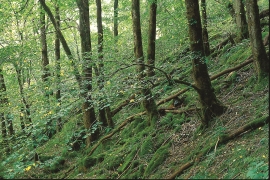
Hopslia
Some of the giant trees in Hopslia north of Holme Fjord are as much as thirty metres high. Elm and ash are the most common, basswood somewhat rarer. Relatively soft bedrock, good growing conditions and enough light, help them to thrive just here.

Skjelbreid
On the east side of Lake Skjelbreidvatnet, clearly visible along the road from Eikelandsosen, we notice a farm on a terrace above a grassy hill. The hill has the form of a broad shield; Skjelbreid (" Broad Shield") is the name of the farm.

Yddal
Yddal is one of the biggest and finest pine forest areas in the county. The rich forest resources provided an important foundation for the settlement of Yddal. Up until about the 1950s, there were three farms here. Where the lumberjacks couldn't get to, the trees grew very big and can be over 300 years old.

Vinnesleira
Bays that are shallow far out into the sea, with fine sand and clay, are rare in Hordaland. Where they are found, the reason is usually that the edge of the glacier made smaller advances or stopovers when it calved back at the end of the last Ice Age. This is what happened at Vinnesleira.

The village of Etne
Much of the sand and gravel that the town of Etne is built on was laid down at the end of the Ice Age and is evidence of melting glaciers and roaring meltwater rivers. The uncompacted material in the big terraces leave their unmistakeable mark on the wide elongated valleys.

Etnedeltaet
During the latter half of the 1900s the big natural river deltas on Westland disappeared. Until the 1980s there was still a small, but significant remnant of the original river delta from the Etneelva river, but today most of this, too, is industrial land.


Skånevik- moraine
In Skånevik there are marks left from the ice edge that advanced during the thousand-year cold spell (Younger Dryas) that marked the end of the Ice Age roughly 11 500 years ago. The glacier first proceeded out into Åkra Fjordand and around Vannes and thereafter sent an arm in toward Skånevik. Here, the glacier lay down an end moraine up against the mountainside.

Mosnes
The permanently-protected Mosneselva River, with its meltwater from Folgefonna, runs out into Åkra Fjord by the roadless and uninhabited Mosnes. Those who once lived here were forced to surrender to the ravages of Nature. In the autumn of 1962 there was a flood so great that the people were driven from their farms.

