- Remove Small landforms filter Small landforms
- Remove Eidfjord filter Eidfjord
- Remove Fusa, frå 2020 ein del av nye Bjørnafjorden kommune filter Fusa, frå 2020 ein del av nye Bjørnafjorden kommune
- Remove Burial mounds filter Burial mounds
- Remove Bronze age filter Bronze age
- Remove Odda, frå 2020 del av nye Ullensvang kommune. filter Odda, frå 2020 del av nye Ullensvang kommune.
- Remove Hydro power filter Hydro power
- Remove Øygarden, frå 2020 del av nye Øygarden kommune. filter Øygarden, frå 2020 del av nye Øygarden kommune.

Eikelandsosen
"So many and such big potholes as are found at Eikelandsosen, we don't see other places in western Norway, and as beautifully polished as the mountainside is along the river up to Koldal , one would look a long time to see anywhere else. There is much to dazzle a geologist's eyes. If only these features could bring others the same joy!"

Hæreid- archaeology
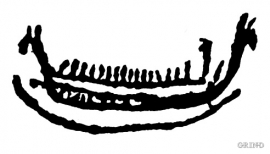
The biggest prehistoric burial site in Hordaland is situated at Hæreid. On top of the terrace expanse, inside the fine birch garden, is where they lie, the mounds and stone piles, on their own or in clusters, large and small, round and elongated – at least 350 in all.

Halne
At Halnefjorden, a few hundred metres east of Halne mountain lodge, lie the remains of two stone sheds – Halnelægeret. Some generations ago the cattle drovers stopped here in the summer; they were the cowboys of their time. But Halnelægeret already had a long history before the cattle drovers came.


Toftestallen
The large coastal waves that crash down on the islands west in the sea gather their energy from storms and winds all the way out in the North Atlantic Ocean. The most common place of origin is nonetheless the North Sea. When these waves break over the skerries and islets along the shore, or on the rocky outermost islands, their energy is released. This takes the form of turbulence in the water and sea spray up on land. Can the enormous energy contained in the waves be exploited?
Tyssedal
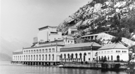
Today Tyssedal appears like a classical industrial community, a picture of modern Norway from the turn of the former century until today. A/S Tyssefaldene was established in 1906, and on 1 May 1908 Tyssedal power station was put into operation. The work on the first stage of the facility was completed in a short time, with a work force of 500 men. They built water tunnels, regulation reservoirs, power station, penstocks, harbour, cableways, office buildings, houses and 6 km of power lines in the wild mountains above Odda to provide the new melting plant with power.

