- Remove Small landforms filter Small landforms
- Remove Deciduous forests filter Deciduous forests
- Remove Late glacial filter Late glacial
- Remove Maritime environments filter Maritime environments
- Remove Seabirds filter Seabirds
- Remove Monastery filter Monastery
- Remove Fitjar filter Fitjar
- Remove Avalanches and rock falls filter Avalanches and rock falls
- Remove Masfjorden filter Masfjorden
- Remove Large landforms filter Large landforms
- Remove Sawmills filter Sawmills
- Remove Trading posts and guesthouses filter Trading posts and guesthouses
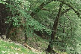

Dyrdal
If you journey along Austfjorden, you at the same time turn the pages of time back through Ice Age history. The landforms show how the landscape has developed gradually as the glaciers have grown - and melted again - in several episodes: from small cirques, we see innermost at Dyrdal, to larger fjords, like at Mas fjord further out.

Mollandseid
In Mollandsvågen, close by the river that runs from Mollandsvatnet (lake) into the fjord, are two water-powered circular saws and a mill. This small industrial centre has belonged to the farms Molland, Reknes and Duesund, which together own the rights to the waterfall

Raunøya
The sea birds discovered it long ago. Raunøya and the surrounding islands are the most beautiful places in Masfjorden.


Engesund
For more than 350 years Engesund has been a place for hostelries and trading in the Fitjar islands. The place is centrally placed in the shipping lane, with a sheltered harbour close to the exposed Selbjørnsfjorden. Engesund was once part of the great network of historical stopover places on the coast.

Færøysund
The old trading post lies at the sound between Stord and Færøy in Langenuen. There was a country store and steamship forwarding agent up to 1964. The trade was then moved over to the new ferry harbour of Sandvikvåg.

Fitjarøyane
If we study the group of islands south of Selbjørns Fjord from the air or on a sea map, we will notice that many of the islands are elongated and lie systematically in rows. The islands are divided by long sounds, for example Trollosen, Nuleia and Hjelmosen, which are oriented in a south-southeast to north-northwesterly direction.

Fitjar- potatoes
The deep agricultural soils in Fitjar are found especially in the area between Lake Storavatnet and Breivika. The many stonewalls in the area reflect that the earth probably was full of stones and stone blocks. The stones that couldn't be dug out had also a function: they stored heat that helped to grow potatoes.


