- Remove Small landforms filter Small landforms
- Remove Lichens, mosses, fungi filter Lichens, mosses, fungi
- Remove Late glacial filter Late glacial
- Remove Middle age filter Middle age
- Remove Maritime environments filter Maritime environments
- Remove Eidfjord filter Eidfjord
- Remove Sediments filter Sediments
- Remove Jondal, frå 2020 del av nye Ullensvang kommune. filter Jondal, frå 2020 del av nye Ullensvang kommune.
- Remove Thrust sheets filter Thrust sheets
- Remove Waterfalls filter Waterfalls
- Remove Kvam filter Kvam
- Remove Glaciers filter Glaciers


Skiftesjøen
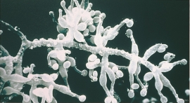
A microscopic mushroom from Hardangervidda has been like a “golden hen” for the Swiss company Novartis. Everywhere in the world, companies are looking for genetic material from nature that can be used for developing new medicines. Occasionally they succeed.

Fruo
At Fruo, nature has built its own little "Chinese wall ". Some kilometers south of the Vøringsfossen waterfall, there are a number of moraine ridges, the longest and most notable of their kind in Hordaland.

Måbødalen- geology
The old pack road had 1500 steps, where cars today gas through the mountain. The time of this hard work is over, and of getting used to the steep terrain, as well; only the view from the top is much the same as before. Vøringsfossen in summer is one of Western Norway’s biggest natural wonders. It marks the transition between the older, open part of the Sysendalen valley and the younger, narrow and winding valley of Måbødalen.


Simadalen
On the 10th of August, 1937, over half of the agricultural land in Simadalen was submerged by the river. The damage to roads and houses was also catastrophic. This was the most destructive flood ever recorded in Hordaland.

Hæreid- geology
The Eidfjord terrace is a gigantic ridge that reaches up more than one hundred metres from the city centre in Eidfjord. It serves as a powerful natural monument left behind by the ice when it retreated.

Sålesnes
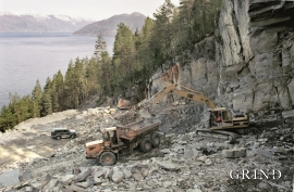
Jondal has one of the country’s oldest slate quarries. Roof tiles have been extracted here since the end of the 1700s, but the quarry is much older. Kvernurdi is mentioned in a diploma in 1421, when Bård Sigurdsson at Torsnes became the owner through a settlement. Already then it must have been customary to cut millstones here.

