- Remove Small landforms filter Small landforms
- Remove Bronze age filter Bronze age
- Remove Maritime environments filter Maritime environments
- Remove Seabirds filter Seabirds
- Remove Monastery filter Monastery
- Remove Fitjar filter Fitjar
- Remove Iron age filter Iron age
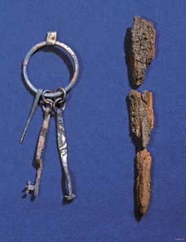
- Remove Modalen filter Modalen
- Remove Os, frå 2020 del av nye Bjørnafjorden kommune filter Os, frå 2020 del av nye Bjørnafjorden kommune
- Remove Churches filter Churches
- Remove Tysnes filter Tysnes

Otterstad
Tthe Otterstad farms lie in the innermost part of Mofjorden, on the northwest side of the river. The row of stave-built boatsheds that belong to the farm were probably constructed a little after the middle of the 1800s. Both here and on the Mo side, the boatsheds were important storage places at the seashore; wood and other farm products intended for the town; corn and merchandise in return.

Fitjar- the King's farm
In front of Fitjar Church there is a memorial stone, sculpted by Anne Grimdalen and erected in 1961, for the thousand-year memorial of one of the most dramatic events in Norway’s history, the Battle of Fitjar. This was the place where Norway’s king, Håkon the Good, suffered his fatal injury in the fight with Eirik’s sons, probably in the year 961.

Rimsvarden
Rimsvarden lies high and unencumbered, an enormous stone mound on the highest top with a wide view of the Fitjar rural community. With its 30 meters across and almost 4 meters high, this is one of the largest prehistoric burial relics existing in Hordaland.


Fluøyane
The richest seabird localities in Bjørna Fjord are FLUØYANE, a group of small and medium-sized islets just east of the entrance to Våge. Here, we see many different nesting birds, but there is the danger that overgrowth will become an obstacle for nesting here in the future. On one of the islands, the environmental protection authority has promised to step in and help the birds.

Årbakka- The prehistoric site
The prehistoric site at Årbakkasanden with menhirs and burial mounds has been visited, described and illustrated by many learned researchers through the last 350 years. All the same, we still know very little of this unique cultural monument.

Grødalshaug
At the bottom of Vargavågen on Halhjem lies Grødalshaug, a 30 metres high rocky outcrop between the bay and a moist valley cleft. On the south side of the rock is a steep rock cliff facing the valley, the bog and the stream. On this rock face we find rock carvings from the Bronze Age.

Lyse chapel
The small white-painted chapel with the red brick tiled roof just south of the monastery ruins at Lyse was built in 1663 as a local chapel for the monastery estate, following the takeover of the property by the District Recorder (Stiftskriver) Niels Hanssøn Schmidt two years previously. The chapel, with its harmonic proportions, lies in the cultural landscape beside the grand monastery estate, witness to a time gone by. But even today, there is a tradition of high mass on the 2nd day of Ascension in Lyse Chapel.

