- Remove Small landforms filter Small landforms
- Remove Mines filter Mines
- Remove Lighthouses filter Lighthouses
- Remove Churches, Cloisters, Christianity filter Churches, Cloisters, Christianity
- Remove Middle age filter Middle age
- Remove Maritime environments filter Maritime environments
- Remove Place filter Place
- Remove Nordhordland filter Nordhordland
- Remove Hardanger og Voss filter Hardanger og Voss
- Remove Vernacular crafts filter Vernacular crafts
- Remove Bedrock filter Bedrock
- Remove Landscape filter Landscape
- Remove Sediments filter Sediments
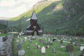
Røldal
The stave church in Røldal was one of the key pilgrimage churches in West Norway. The church was probably built between 1250 and 1350, and in the high Middle Ages Røldal was the most important destination for pilgrims in the country beside the Nidaros cathedral. It was the crucifix that attracted people to midnight mass on midsummer night. That was when it excreted its miraculous sweat.

Eidfjord church
The old stone church at Eidfjord has an open position on the terrace at Lægreid. In a diploma from 1310 it transpires that Torgeir on Sponheim donated a gift for the erection of the church in Eidfjord. Thus we can assume that the church was under construction at the time. The elements in the style confirm such a dating.


Fruo
At Fruo, nature has built its own little "Chinese wall ". Some kilometers south of the Vøringsfossen waterfall, there are a number of moraine ridges, the longest and most notable of their kind in Hordaland.

Hæreid- geology
The Eidfjord terrace is a gigantic ridge that reaches up more than one hundred metres from the city centre in Eidfjord. It serves as a powerful natural monument left behind by the ice when it retreated.


Jomfrunuten
Freezing and thawing are processes that influence plant cover, move enormous blocks, stretche long mounds of earth, break open bedrock and create patterns in stone and earth.

Rallarvegen
They rest there, all as one, the silent witnesses of Western Norway's saga of creation: Precambrian basement, phyllite and thrust sheet. In the end came the glaciers and sculptured the vast landscape. Along the ground or on the horizon, from bicycle or on foot - the landscape tells its story - and it tells it clearer on Rallarvegen than many other places.

Ulvik-village
The ice cap that covered the land during each of the 40 past ice ages over the past 2 million years of Earth's history pressed down the crust of the earth - like a finger on a rubber ball. And when the ice finally loosened its grip 11,000 years ago, the earth's crust rose again, most where the ice was thickest, least where it was thin, quickly in the beginning, and later more slowly. To this day, the land in the inner part of Norway continues to rise by perhaps one millimetre per year. By and large, however, the crust in Hordaland has again reached equilibrium after the weight of the ice was removed.

