- Remove Small landforms filter Small landforms
- Remove Radøy, frå 2020 del av nye Alver kommune. filter Radøy, frå 2020 del av nye Alver kommune.
- Remove Ullensvang, frå 2020 del av nye Ullensvang kommune. filter Ullensvang, frå 2020 del av nye Ullensvang kommune.
- Remove Wetland filter Wetland
- Remove Maritime environments filter Maritime environments
- Remove Seabirds filter Seabirds
- Remove Monastery filter Monastery
- Remove Fitjar filter Fitjar
- Remove Avalanches and rock falls filter Avalanches and rock falls
- Remove Etne filter Etne
- Remove Igneous rocks filter Igneous rocks
- Remove Fedje filter Fedje
- Remove Modalen filter Modalen
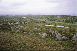
Fedje bog
The wild rabbit is really native to Northwest Africa, but the Ancient Romans introduced them to large parts of Europe. Not to Norway, rightly enough: the population on Fedje originated from 3-4 pairs that were brought here from the Shetland Isles in 1875, making this their first residence in the country.

Stormark
Both the climate and people have been decisive in shaping the bog landscape on Fedje - a landscape that has been evolving over several thousands of years. The peat got built up layer for layer and provided income and fuel for the people of Fedje.

Nedre Helland- skred
Many still remember when the avalanche struck Nedre Helland, on the 14th of August, 1953 14:30 o'clock. All of the buildings at one of the farms and the main house on the neighbouring farm were destroyed. The one woman who was inside a building escaped, frightened but unharmed. The same with the others who lived at Nedre Helland; everyone was a safe distance from the avalanche.

Otterstad
Tthe Otterstad farms lie in the innermost part of Mofjorden, on the northwest side of the river. The row of stave-built boatsheds that belong to the farm were probably constructed a little after the middle of the 1800s. Both here and on the Mo side, the boatsheds were important storage places at the seashore; wood and other farm products intended for the town; corn and merchandise in return.


Manger
Mangerite is a rock type that was first made famous in a treatise by the Bergen geologist Carl Fredrik Kolderup in 1903. The rock type got its name from the place where it was found, and has made the Mangerud name well known around the world, at least among geologists.

Toska
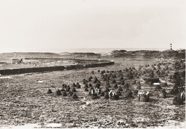
The peat bogs on Toska have been mined for peat since 1946, when the island got electricity. In this treeless coastal landscape, peat was the most important source of energy, and this took quite a toll on the bogs.

Etnedeltaet
During the latter half of the 1900s the big natural river deltas on Westland disappeared. Until the 1980s there was still a small, but significant remnant of the original river delta from the Etneelva river, but today most of this, too, is industrial land.

Fitjarøyane
If we study the group of islands south of Selbjørns Fjord from the air or on a sea map, we will notice that many of the islands are elongated and lie systematically in rows. The islands are divided by long sounds, for example Trollosen, Nuleia and Hjelmosen, which are oriented in a south-southeast to north-northwesterly direction.

