- Remove Small landforms filter Small landforms
- Remove Ulvik filter Ulvik
- Remove Lakes, rivers and river networks filter Lakes, rivers and river networks
- Remove Maritime environments filter Maritime environments
- Remove Seabirds filter Seabirds
- Remove Monastery filter Monastery
- Remove Fitjar filter Fitjar
- Remove Avalanches and rock falls filter Avalanches and rock falls
- Remove Fjell, frå 2020 del av nye Øygarden kommune filter Fjell, frå 2020 del av nye Øygarden kommune
- Remove Sediments filter Sediments
- Remove Trading posts and guesthouses filter Trading posts and guesthouses
- Remove Mountain plants filter Mountain plants
Finse
Many mountain plants are well prepared to face cold and wind. Some would surely rather face an easier life in the lowlands, but they cannot compete with the higher-growing plants living there. Most mountain plants manage to compete for light and space only if they cling to the bedrock and gravel in the harsh high alpine climate.

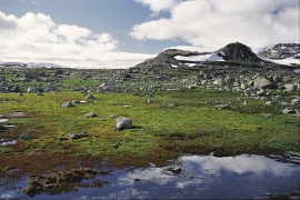
Jomfrunuten
Freezing and thawing are processes that influence plant cover, move enormous blocks, stretche long mounds of earth, break open bedrock and create patterns in stone and earth.

Rallarvegen
They rest there, all as one, the silent witnesses of Western Norway's saga of creation: Precambrian basement, phyllite and thrust sheet. In the end came the glaciers and sculptured the vast landscape. Along the ground or on the horizon, from bicycle or on foot - the landscape tells its story - and it tells it clearer on Rallarvegen than many other places.

Solskinstjørni
Solskinstjørni in Osa, just above Haugen farm in Norddalen, is visible only now and again, seemingly always for a period of good weather. Then it disappears abruptly, but its disappearance is not connected to weather conditions.


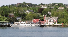
Ulvik-village
The ice cap that covered the land during each of the 40 past ice ages over the past 2 million years of Earth's history pressed down the crust of the earth - like a finger on a rubber ball. And when the ice finally loosened its grip 11,000 years ago, the earth's crust rose again, most where the ice was thickest, least where it was thin, quickly in the beginning, and later more slowly. To this day, the land in the inner part of Norway continues to rise by perhaps one millimetre per year. By and large, however, the crust in Hordaland has again reached equilibrium after the weight of the ice was removed.
Brattholmen
The old guesthouse location in Brattholmen on the east side of Litlesotra, was probably established in the first half of the 1700s. A list from 1748 mentions that the place “for some years has been inhabited by an Enrolled Sailor by the name of Peder Michelsen”. As was the case for most other military hosts, he was exempt from paying income tax.

Fjell river network
There are many river networks out by the coast and they tend to be small and unassuming. The farmer has relied upon the watercourses to run his mill and saw, and it may be that the trout have given him a good source of food in years when the ocean fish failed. In our time, these river networks are being rediscovered for their value in recreation and outdoor life, and several places, tourist trails have been built in order to fully enjoy them.

Landro
Landro has been the largest estate on Sotra, including 15 farms with reasonable conditions for agriculture. Their boathouses have had an excellent harbour in Landrovågen. Landro thus has been a good basis for the combination of agriculture and fishing.

Langøy
Up to 1842 it was necessary to have a royal letter of privilege in order to carry out trade. According to the law only city dwellers were allowed to obtain such a privilege, and in Hordaland it was thus the citizens of Bergen who owned and ran the trading centres. In 1842, following a liberalisation of the trading legislation, the privilege arrangement was abandoned and anyone could apply to the municipal council for permission to carry out trading activity. Landøy is one of the places that were established in this period.

