- Remove Modalen filter Modalen
- Remove Cultural landscapes filter Cultural landscapes
- Remove Metamorphic rocks filter Metamorphic rocks
- Remove Lakes, rivers and river networks filter Lakes, rivers and river networks
- Remove Austrheim filter Austrheim
- Remove Nordhordland filter Nordhordland
- Remove Vaksdal filter Vaksdal
- Remove Meland, frå 2020 del av nye Alver kommune. filter Meland, frå 2020 del av nye Alver kommune.
- Remove Middle age filter Middle age
- Remove Trading posts and guesthouses filter Trading posts and guesthouses
- Remove Lindås, frå 2020 del av nye Alver kommune. filter Lindås, frå 2020 del av nye Alver kommune.
- Remove Masfjorden filter Masfjorden
- Remove Maritime environments filter Maritime environments


Bergsdalen
The mountains of western Norway are lovely to wander in. In Cambro-Silurian time it was the mountain itself that wandered. The mountain, or more correctly the bedrock, first moved eastward, then back a bit westward again. All this rocking back and forth in the mountains ended about 400 million years ago.
Bruknappen
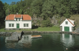
The hostelry place in Bruknappen is situated north in Radsundet, just south of Festo, by a sheltered idyllic bay, close to the main lane. Sloops both from Sognefjorden and Nordland had their fixed stops at “the blacksmith in Bruknappen”; on their way to Bergen, fully loaded with wood and hazel hoops, barrels and chests, or on their way home with town merchandise.

Eksingedalen- hydropower development
Water discharge at the outlet of the Ekso into Eidsfjord was halved after the big hydropower development in the mountainous area between Modalen and Eksingedalen and further southward toward Evanger in the 1960s, 70s and 80s. In an attempt to amend the changed environmental conditions in the waterway the developer built 35 small dams in the river.

Ekso
In the late 1800s, Ekso was known among the nobility in England as having among the best salmon rivers. In summer the Lords could haul in big fish of up to 25 kg. In return, the townsfolk were paid for fishing rights, lodging and local assistance.

Eldsfjellet
The eclogites in western Norway were formed when Precambrian basement rocks were squeezed and pressed down under great pressure deep under the Caledonian mountain chain. The process may well have triggered some of the deepest earthquakes the world has ever known. The clearest traces of this drama are found in and around Mt. Eldsfjellet, in peaceful Meland.

Frøyset river network
Frøyset river network is protected from power station-building - not because of its pristine nature - but because it is a typical river network for this part of western Norway.


Holmeknappen
If you come by sea to Bergen and come up the Herdle Fjord, the yellow ochre marine shed at Holmeknappen is a well known landmark to starboard as you come close to the little shore settlement. In olden days Holmenknappen served important functions as a centre for a wide hinterland of the surrounding farms, warehouse, landing point, country store and later a steamer quay, a hotel (1896) and a dairy (1909). But today Holmeknappen is no longer a focal point. Transport and commercial routes have changed the old pattern

Husebø
When the Corncrake returned to Nordhordland, it came as no surprise that Husebø was the place it chose. Here, remnants of the old cultural landscape are still in good condition. And the Corncrake is not alone in appreciating this.

