- Remove Øygarden, frå 2020 del av nye Øygarden kommune. filter Øygarden, frå 2020 del av nye Øygarden kommune.
- Remove Basement rocks filter Basement rocks
- Remove Archaeological findings filter Archaeological findings
- Remove Archaeology filter Archaeology
- Remove Sund, frå 2020 del av nye Øygarden kommune filter Sund, frå 2020 del av nye Øygarden kommune
- Remove Place filter Place
- Remove Granvin, frå 2020 del av nye Voss herad filter Granvin, frå 2020 del av nye Voss herad
- Remove Radøy, frå 2020 del av nye Alver kommune. filter Radøy, frå 2020 del av nye Alver kommune.
- Remove Bedrock filter Bedrock

Lussand- geology
Hardangerfjorden kløyver Hordaland i to. Den etter måten rettlinja fjorden skjer seg liksom på skeive inn i landet. Ikkje som Sognefjorden og Nordfjord – dei krokar og buktar seg innover meir eller mindre vinkelrett på kysten. Hardangerfjordens utforming har røter 400 millionar år tilbake i tida, då den veike sona i fjellet, der isen seinare tok grådig for seg, vart danna. Denne sona stig på land ved Lussand.


Golta- Gneiss
Over thousands of years, autumn storms and strong land-driving winds have cleaned the bare rocks of Golta. The waves can beat far in over land and make it dangerous to walk along the shoreline. When the storms have calmed, the results of their work comes into view.


Tyssøy
B.E.Bendixen, who has written about “The Churches in Søndre Bergenhus Amt”, believed even around 1900 that there was evidence at Tyssøy of the church or the chapel of the Holy Ludvig (Louis). Two large stone blocks had lain in the western wall of the church’s nave, and this wall showed a length of 16 meters in the terrain.

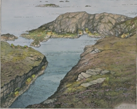


Fosnstraumen
At the southern end of the bridge between Radøy and Fosnøy archaeologists found an unusual Stone Age settlement. There was a thick “cultural layer” here with the remains of the waste dumps of a hunting people. The place was called Kotedalen. Here they came, one group after the other, and settled for some weeks, some months, or maybe years before they went on, leaving the settlement deserted. Time after time it happened. At least 16 settlement phases have been identified, stretching over 5,500 years.

