- Remove Øygarden, frå 2020 del av nye Øygarden kommune. filter Øygarden, frå 2020 del av nye Øygarden kommune.
- Remove Basement rocks filter Basement rocks
- Remove Midthordland filter Midthordland
- Remove Hydro power filter Hydro power
- Remove Churches filter Churches
- Remove Iron age filter Iron age
- Remove Bergen filter Bergen
- Remove Sediments filter Sediments
- Remove Samnanger filter Samnanger
![The Boat Hall at the Horda Museum houses 26 clinker-built, open wooden boats](https://www.grind.no/sites/default/files/styles/medium/public/bilder/sted/190/kvh_266_hordamuseet_2_150_0.jpg?itok=hUA-sFmd)
![This is what the northernmost part of the fishing village might have looked like in Viking times](https://www.grind.no/sites/default/files/styles/medium/public/bilder/sted/232/kvh_288-4.jpg?itok=mGnXIxYE)
![Toftestallen](https://www.grind.no/sites/default/files/styles/medium/public/bilder/sted/232/bo_13.jpg?itok=zrSHKUwq)
Toftestallen
The large coastal waves that crash down on the islands west in the sea gather their energy from storms and winds all the way out in the North Atlantic Ocean. The most common place of origin is nonetheless the North Sea. When these waves break over the skerries and islets along the shore, or on the rocky outermost islands, their energy is released. This takes the form of turbulence in the water and sea spray up on land. Can the enormous energy contained in the waves be exploited?
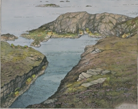
![This little mountain in the picture sticks up because the layers are tilted on their sides.](https://www.grind.no/sites/default/files/styles/medium/public/bilder/sted/232/oygard_21.jpg?itok=ugcTumKb)
![Lona in April](https://www.grind.no/sites/default/files/styles/medium/public/bilder/sted/232/sam_19.jpg?itok=cZuecxsb)
Lona
One does not need much imaginationto see that where the river bends down in Røssebotnen, there has once been a lake. The landscape tells this - more clearly than any book.
![Frøland power station and lake Frøland.](https://www.grind.no/sites/default/files/styles/medium/public/bilder/sted/232/sam_4.jpg?itok=7O9c4Igu)
Frøland
Much rain, a steep drop and nearness to Bergen meant that the power-making potential of the Samnanger water system was exploited early. Samnanger was thus one of the first power-producing municipalities in western Norway. With its subsequent expansion and new power stations, about 400 gigawatts of electricity per hour were produced on average each year. This is enough to meet the energy needs of 25,000 households.
![The church at Kyrkjebyrkjeland was pulled down in 1878.](https://www.grind.no/sites/default/files/styles/medium/public/bilder/sted/232/kvh-267-1x.jpg?itok=fL3_DjIv)
![Fantoft stave church](https://www.grind.no/sites/default/files/styles/medium/public/bilder/sted/190/kvh_267_fantoft_150.jpg?itok=hZdUT-Rm)
![Domkirken](https://www.grind.no/sites/default/files/styles/medium/public/bilder/sted/190/kvh_256_domkirken_150.jpg?itok=kfZkGtiZ)
![Korskirken](https://www.grind.no/sites/default/files/styles/medium/public/bilder/sted/190/korskirken.jpg?itok=LK8XAlZN)