- Remove Settlements, Villages, Towns filter Settlements, Villages, Towns
- Remove Modalen filter Modalen
- Remove Vaksdal filter Vaksdal
- Remove Landscape filter Landscape
- Remove Etne filter Etne


Eksingedalen- landscape
Eksingedalen alternates between wide, flat flood plains with good farmland, and narrow passages with waterfalls where the roads cling to the mountainsides. The alternations in the landscape are a result of the sculpturing work by glaciers over several ice ages, and the deposition of the glacial river deposits when the last glacier finally melted back.

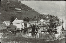
Etnedeltaet
During the latter half of the 1900s the big natural river deltas on Westland disappeared. Until the 1980s there was still a small, but significant remnant of the original river delta from the Etneelva river, but today most of this, too, is industrial land.

Gullbrå
From written sources we know that the farm Gullbrå was in use early in the 1600s. The Apostolic church in Bergen owned land here that it rented out, but even early in the 1600s some of the land was in private ownership. Eksingedalen then belonged to Modalen parish, which was under Hamre parish. In 1723 the Apostolic church still had properties here, and Ivar and Lars were farmers.

Krokavatnet
On Sunday the 29th of January, 1989, at 17:38 o'clock, Etna shook. The earthquake, with its epicentre ca. 9 kilometres south of Etne centre, had a strength of 4.2 on the Richters scale. This could be felt over large parts of West Land, especially in the areas around Åkra, Etne, Hardanger Fjord and Sauda Fjord. The earthquake was the largest that has ever been measured in Hordaland.
Kyrping
The trading post down by the fjord at Kyrping does not belong to the oldest group of trading posts from the 1600s and 1700s. It was only after the liberalisation of the trading legislation that trade was established here.


Mosnes
The permanently-protected Mosneselva River, with its meltwater from Folgefonna, runs out into Åkra Fjord by the roadless and uninhabited Mosnes. Those who once lived here were forced to surrender to the ravages of Nature. In the autumn of 1962 there was a flood so great that the people were driven from their farms.

Mostraumen
Until 1743 the people from Modal had to wait for a flood in MOSTRAUMEN before they could draw their boats up the river current, and then row back across Lake Movatnet. But, that year the flood opened a free passageway all the way to Mo. Hordaland had gained a new tidal waterway.

Nedre Helland- skred
Many still remember when the avalanche struck Nedre Helland, on the 14th of August, 1953 14:30 o'clock. All of the buildings at one of the farms and the main house on the neighbouring farm were destroyed. The one woman who was inside a building escaped, frightened but unharmed. The same with the others who lived at Nedre Helland; everyone was a safe distance from the avalanche.

