- Remove Museums, nature conservation, cultural heritage filter Museums, nature conservation, cultural heritage
- Remove Hydro power filter Hydro power
- Remove Arkeologi filter Arkeologi
- Remove Museum filter Museum
- Remove Vernacular arts filter Vernacular arts
- Remove People and Society filter People and Society
- Remove Farm sites filter Farm sites
- Remove Settlements, Villages, Towns filter Settlements, Villages, Towns
- Remove Skule filter Skule
- Remove Industry, Energy and Natural Resources filter Industry, Energy and Natural Resources
- Remove Lakes, rivers and river networks filter Lakes, rivers and river networks
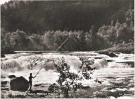
Vosso
There is probably no bigger salmon to be found in the whole wide world than in Vosso. The average size varies from season to season of course, but for many years this fish has had an average weight of over 10 kilograms. Thumping big ones of 30 kg. have been fished from the river, but one must go back to the 1940s for the last salmon of this size last that was caught.
Fjose
The farm Fjose lies uppermost in Tjukkebygdi, one of the good grain farms on the sunny side here. The woodcarver Styrk Fjose (1873-1937) came from this farm, which is now protected as a cultural heritage.


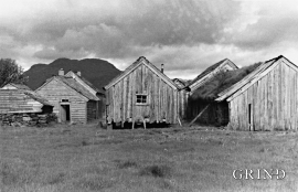
Hjølmo
In the steep hillside in Hjølmodalen, a small side valley from Øvre Eidfjord (Upper Eidfjord), which has been a key entrance to the Hardanger Plateau, the hamlet of old farmhouses still lie clustered together. The yard is empty today, some of the houses are used in the summer, but the grass grows round all the corners.

Måbø
Måbø is the uppermost farm in Måbødalen. This narrow and steep mountain valley has been one of the routes from the fjord communities up to the mountain plateau from times immemorial. We are not certain of the meaning of the name Måbø. Perhaps it has its origin in an Old Norse male name Mávi, from the name for seagull, már. The last syllable “bø” means farm. Today Måbø gives us a compact close-up of the subsistence economy: the small farm with the clearance piles, stone walls and a lane that guided the animals into the yard, at the foot of the great mountain expanse.

Einstapevoll- the farm
Einstapevoll (from einstape: “bregne” (fern)) lies on the west side of the Tittelsnes peninsula. Up to 1831 the farm was a vicarage belonging to Stord parish. The priests had leasing rights. Land rent and other fees from the farm was part of their salaries.

Haugsbø
The single unit farm without a road to it, Haugsbø, is situated on the east side of the Tittelsnes peninsula facing Ålfjorden. As far back as the Middle Ages the farm has probably belonged to Stord Parish, up to the 1800s. In 1590 it was thought to be abandoned, but in 1601 Mickel Hougsbøe paid a tithe on the farm.
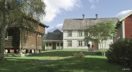
Sæbøtunet
When you come into the well-tended farm steading at Sæbø just above Etne centre, you get the impression of a Sunnhordland farm from well before the time of the tractor; from the time of the horse and the scythe. The hamlet at Sæbø, one of the farms neighbouring to Gjerde, was taken over by Sunnhordland Folk Museum in 1938.

Rosendal Barony
The Barony of Rosendal lies in the grounds of the old noble estate of Hatteberg, on the north side of the Hatteberg river, around one kilometre up from the sea. The three noble estates Seim, Mel and Hatteberg constituted the core of the large estate taken over by Ludvig Rosenkrantz in 1662, after he was married to Karen Mowat in 1658.
Litlabø
The first finds of pyrite at Litlabø in Stord came to light in 1864. Forty years later sulphuric ore was mined from an open mine. From 1874 to 1880 it was used for dynamite production. That came to a sudden end when the factory exploded and three people died.

