- Remove Smallholdings filter Smallholdings
- Remove Music filter Music
- Remove Sunnhordland filter Sunnhordland
- Remove Museum filter Museum
- Remove Trading posts and guesthouses filter Trading posts and guesthouses
- Remove Igneous rocks filter Igneous rocks
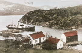
Neshamn
Neshamn must be an ancient place for meeting and spending the night for travellers. The place blossomed in connection with the times of economic expansion in the 1500s, which to a large extent was linked to the Scottish trade at this time. Neshamn was a loading place for Scottish ships for two hundred years, up to the middle of the 1700s.


Færøysund
The old trading post lies at the sound between Stord and Færøy in Langenuen. There was a country store and steamship forwarding agent up to 1964. The trade was then moved over to the new ferry harbour of Sandvikvåg.

Ådlandsstova
The Ådland house is one of the biggest medieval houses still existing in West Norway. It is constructed from unusually large, hard fir wood, beautifully oval-cut. One story links the cottage to the Gildeskålbakken at Orninggård (Lower Ådland); thus indicating that the cottage has been the medieval banqueting hall. The building has been dated back to the 13-1400s by carbon dating.

Leirvik- The trading post
Already in the Middle Ages the good harbour at Leirvik provided a connecting point. Here was a court of law, and a guesthouse was established here in the 1600s. But Leirvik never achieved the status of a trading post or a ship-loading place. In the census of 1865 parts of the farms Nordre Bjelland, Leirvik and Orninggård are mentioned as the “Coastal district of Lervig”. And the community grew around the old guesthouse location early in the 1800s.


Espevik
220 million years ago, glowing hot molten rock masses intruded into fractures in the earth's crust in the outer parts of Hordaland. Some of these are believed to have reached the surface and formed lava flows, which since have been eroded away by wind and weather. But, most of these flows solidified into diabase sills before they got to the surface.

Fitjarøyane
If we study the group of islands south of Selbjørns Fjord from the air or on a sea map, we will notice that many of the islands are elongated and lie systematically in rows. The islands are divided by long sounds, for example Trollosen, Nuleia and Hjelmosen, which are oriented in a south-southeast to north-northwesterly direction.

Kattnakken–Stovegolvet
The highest mountainous area on Stord, including Kattnakken, Midtfjellet and Stovegolvet, has more in common with the mountainous terrain on the mainland than in the low coastal landscape of Sunnhordland. The volcanic bedrock together with the erosive powers of nature has resulted in a unique plateau landscape.


