- Remove Cultural landscapes filter Cultural landscapes
- Remove Samnanger filter Samnanger
- Remove Voss, frå 2020 del av nye Voss herad. filter Voss, frå 2020 del av nye Voss herad.
- Remove Archaeological findings filter Archaeological findings
- Remove Literature filter Literature
- Remove Lindås, frå 2020 del av nye Alver kommune. filter Lindås, frå 2020 del av nye Alver kommune.
- Remove Faults filter Faults

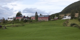
Byrkjehaugen
On the farm Bø, close to the highway between Bulken and Voss lies Byrkjehaugen, one of the largest burial mounds in West Norway. Originally it was around 50m across and 5m high, but following the excavation in 1908 and chipping off by both railway and road construction, the cross-section has shrunk to 37m and the height to 4m. All the same, it is an impressive burial monument for the passing traveller to see.

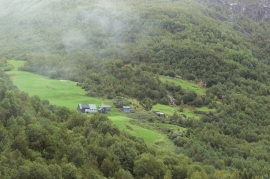
Holo
I Kvassdalen var det aktiv stølsdrift med mjølking av kyr og geitehald nokre år inn i vårt tusenår, og slik hadde det vore i meir enn to hundre år. Såleis har dalen ikkje fått gro til med kratt og skog, men er open og lys. Fortsett er det beiting av kyr og sauer.

Lurekalven
Lurekalven is an unpopulated island of heather moor which is a part of the wilderness belonging to the five farms on Ytre Lygra. Between the two islands there is only a small sound. As late as the 1920s, milking cows were rowed over the sound from Lygra in summer – a form of farming that was adapted to the coastal landscape.

Lygra
The heath landscape on outer Lygra, Utluro and Lurekalven will in future become part of a landscape protection area, to be maintained through traditional activities with year-round outdoor sheep, grazing and burning. The West Norwegian heath country belongs to a large North Atlantic coastal landscape stretching from the Bay of Biscay to the Lofoten islands.


Stall
The Bergen Arcs have an unusually sharp boundary to the bedrock in the east. Geologists think that this was caused by movements in the earth's crust during the Devonian Period. Then, the Bergen Arcs on the Lindås peninsula sank a whole 10 kilometres in relation to the Precambrian basement gneisses on the east side of Fens Fjord and Aust Fjord.

