- Remove Small landforms filter Small landforms
- Remove Tourism filter Tourism
- Remove Wetland filter Wetland
- Remove Coniferous forests filter Coniferous forests
- Remove Hardanger og Voss filter Hardanger og Voss
- Remove Late glacial filter Late glacial

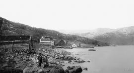
Odda- The tourist town
The pioneering tourists in the 1830s-40s brought a momentum in the tourist traffic to the fjord and mountain country Norway. At the time Odda was a hidden Shangri-La at the bottom of Sørfjorden; the farm and the church on the green headland at the fjord. But when the steamship traffic opened the fjord landscape for tourism, in a few years Odda parish in Søndre Bergenhus County became the focal point for travellers in West Norway.
Utne
When sergeant Peder Larsen Børsem from Strandebarm was “demobilised” in 1721, following the large Nordic War, he married the Bergen lady Elisabeth Schrøder and settled as innkeeper at Utne with a letter of privilege from the county governor dated 29 October 1722.


Fruo
At Fruo, nature has built its own little "Chinese wall ". Some kilometers south of the Vøringsfossen waterfall, there are a number of moraine ridges, the longest and most notable of their kind in Hordaland.

Hæreid- geology
The Eidfjord terrace is a gigantic ridge that reaches up more than one hundred metres from the city centre in Eidfjord. It serves as a powerful natural monument left behind by the ice when it retreated.


Langavassmyrane
The Ruff lek on Langvassmyrane is the only known phenomenon of its kind on Hardangervidda. Every year it attracts hens from the whole plateau. The marsh is also the richest wetland in the county. This green oasis is located in a rocky moraine landscape a few hours walking distance south of Dyranut.

Granvinsvassdraget
After the ice age, Granvin Fjord reached all the way up under Skjervsfjossen waterfall. Just a thousand years later, as a result of the rising of the land after the ice melted, this whole inner part of the fjord freed itself of the sea and became Granvinsvatnet lake. In spite of this rise in elevation, this waterway is still navigable for fish: Sea trout have wandered into Granvinsvatnet in more recent times and evolved to become freshwater trout. And salmon and sea trout made the journey 13 kilometres up the Storelvi river.


Skjervet- river theft
At the end of the last ice age the ice flowed out of Hardanger fjord in such a fury that it forced the meltwater from Voss to run back uphill toward Granvin. The glacier from Raundalen down the windy valley along the Vosso to Bolstadøyri went too slow to make the turn.

