- Remove Trading posts and guesthouses filter Trading posts and guesthouses
- Remove Large landforms filter Large landforms

Tokagjelet
There is a sharp transition between the wide valley at Kvamskogen and the narrow Tokagjelet. The transition is no less dramatic when we come out of the crooked tunnels far down in the canyon, and the open Steinsdalen valley spreads out before us. The canyon both separates and joins together different epochs in western Norway's history.

Odda- The tourist town
The pioneering tourists in the 1830s-40s brought a momentum in the tourist traffic to the fjord and mountain country Norway. At the time Odda was a hidden Shangri-La at the bottom of Sørfjorden; the farm and the church on the green headland at the fjord. But when the steamship traffic opened the fjord landscape for tourism, in a few years Odda parish in Søndre Bergenhus County became the focal point for travellers in West Norway.
Utne
When sergeant Peder Larsen Børsem from Strandebarm was “demobilised” in 1721, following the large Nordic War, he married the Bergen lady Elisabeth Schrøder and settled as innkeeper at Utne with a letter of privilege from the county governor dated 29 October 1722.

Brandasund
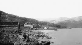
On Gisøya Island, on the west side of Brandasund Sound, there is a very privileged trading post and traveller's Inn from the 1600s, with the North Sea as its nearest neighbour. In 1991 a road was built over Bømlo out to these islands, but for thousands of years the sheltered harbour here was a main stopping place along the outer coast. During the great herring period of the 1700s and 1800s, Brandasund was a centre for the herring fisheries on the Sørafeltet fishing grounds. Today, the area belongs to the municipality of Bømlo.

Sandviksfjellet
On Sandviksfjellet there are old boulders that have been made into mountains. The stones have been stretched out or squeezed together between huge slabs of rock, during slow, but powerfulprocesses of transport. This conglomerate shows, in quite a special way, the enormous powers that were active during the collision between Norway and Greenland over 400 million years ago.

Isdalen
The valley on the inside of the Svartediks dam, a five minutes' bus ride from Bergen centre, is often referred to by Bergen folk as Isdalen ("Ice Valley") - justifiably, since the area could have been described in textbooks for its ice-carved land forms. The glacier's polishing over ca. 40 ice ages has created a magnificient landscape. The original ice valley climbs up behind Ulriken at the end of Svartediket.

Hårteigen
Hårteigen, «the grey signpost», as the name suggests, is a landmark for mountain hikers on the western plateau. The piece of mountain is also a monument for the mighty rock layers that once covered the entire plateau.

Melderskin
MELDERSKIN - ONCE A NUNATAK? Melderskin, the towering and majestic landmark at Rosendal, rises 1462 metres above sea level. The top area is smooth, but slightly inclined. Geologists think that the area is a remnant of a weakly undulating landscape, that originated near the sea, long before the Ice Age set in.


