- Remove Smallholdings filter Smallholdings
- Remove Faults filter Faults
- Remove Iron age filter Iron age
- Remove Quarries filter Quarries
- Remove Civil servant dwellings and manors filter Civil servant dwellings and manors

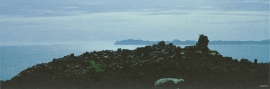
Fitjarøyane
If we study the group of islands south of Selbjørns Fjord from the air or on a sea map, we will notice that many of the islands are elongated and lie systematically in rows. The islands are divided by long sounds, for example Trollosen, Nuleia and Hjelmosen, which are oriented in a south-southeast to north-northwesterly direction.


Sørhuglo
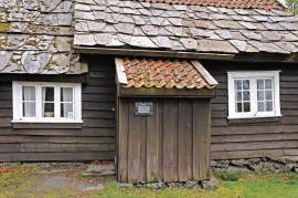
The tax collector’s farm at Sørhuglo is one of the many farms for state employees in Hordaland. According to history, “Futastovo” was built by the tax collector Gram in the second half of the 17th century. In 1943 the building was moved to Sunnhordland Folk Museum.

Einstapevoll- the farm
Einstapevoll (from einstape: “bregne” (fern)) lies on the west side of the Tittelsnes peninsula. Up to 1831 the farm was a vicarage belonging to Stord parish. The priests had leasing rights. Land rent and other fees from the farm was part of their salaries.
Tjernagel
For almost three thousand years Tjernagelshaugen (the Tjernagel cairn) has lain as a landmark at the Bømlo fjord. The poet Torarin mentions the cairn in his account of Knut the Mighty, who in the year of 1028 sailed from Denmark to Nidaros: “And in front of the old cairn at Tjernagel sailed soldiers sharp with peace”.


Årbakka- The prehistoric site
The prehistoric site at Årbakkasanden with menhirs and burial mounds has been visited, described and illustrated by many learned researchers through the last 350 years. All the same, we still know very little of this unique cultural monument.

Byrkjehaugen
On the farm Bø, close to the highway between Bulken and Voss lies Byrkjehaugen, one of the largest burial mounds in West Norway. Originally it was around 50m across and 5m high, but following the excavation in 1908 and chipping off by both railway and road construction, the cross-section has shrunk to 37m and the height to 4m. All the same, it is an impressive burial monument for the passing traveller to see.
Nordheim
"And here these endless kingdoms and these toils for a rich working life far and wide have lain and slept for a hundred thousand years! Right up until the Voss Railway came in 1883 and woke them, like the prince in the fairytale who awakened the Sleeping Beauty."

