- Remove Smallholdings filter Smallholdings
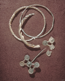
- Remove Archaeological findings filter Archaeological findings
- Remove Maritime environments filter Maritime environments
- Remove Plants by the sea filter Plants by the sea
- Remove Road constructions filter Road constructions
- Remove Hydro power filter Hydro power

Stalheimskleiva
From the oldest times on record in Norway one of the most important traffic arteries between west and east Norway has passed across Bolstad – Voss – Stalheim – Gudvangen and Lærdal. The post road between Oslo and Bergen was established here 1647, but in Stalheimskleiva there was only a packhorse track right up to the 1840s. Wheeled transport and carts were in little use in the mountains in West Norway up to that time.

Berge
Down by the fjord on the farm Berge in Tørvikbygd, is Stekkavika – a sheltered eastward facing harbour, protected against the fjord by headlands and rocks, even manifest in the name. Here is also a comprehensive milieu of coastal industry, with boathouses and sea-sheds that belong to the farms Berge, Heradstveit and Halleråker. Belonging to the farm Berge there is also a mill-house, circular saw, workshop for sloop building, and – a little further up into the woods – the old water-powered sash-saw.

Bru
Bruosen is one of the few river harbours in the county. As landing place for the churchgoers, this place and the boatshed environment follow a tradition that goes back to the Middle Ages, but the country store of today is much younger.


Tokagjelet
There is a sharp transition between the wide valley at Kvamskogen and the narrow Tokagjelet. The transition is no less dramatic when we come out of the crooked tunnels far down in the canyon, and the open Steinsdalen valley spreads out before us. The canyon both separates and joins together different epochs in western Norway's history.

Dyrskard
Right from the start the road across Haukelifjell was a road from “fjord to fjord”, from the bottom of Sørfjorden to Dalen in Telemark. The connection between Røldal-Haukelifjell was considered so important by Stortinget (Parliament) that the road construction Odda-Dalen was approved already in 1853.

Reinsnos
The mountain settlement Reinsnos is situated at nearly 700 metres above sea level at the end of the Reinsnos lake; an entry point to the Hardanger plateau.

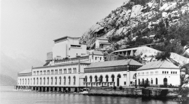
Tyssedal
Today Tyssedal appears like a classical industrial community, a picture of modern Norway from the turn of the former century until today. A/S Tyssefaldene was established in 1906, and on 1 May 1908 Tyssedal power station was put into operation. The work on the first stage of the facility was completed in a short time, with a work force of 500 men. They built water tunnels, regulation reservoirs, power station, penstocks, harbour, cableways, office buildings, houses and 6 km of power lines in the wild mountains above Odda to provide the new melting plant with power.

