- Remove Small landforms filter Small landforms
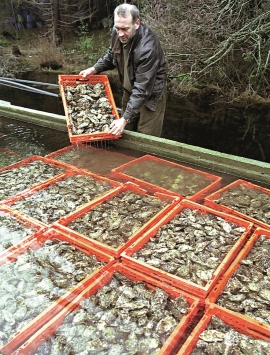
- Remove Fisheries filter Fisheries
- Remove Civil servant dwellings and manors filter Civil servant dwellings and manors
- Remove Igneous rocks filter Igneous rocks
- Remove Large landforms filter Large landforms

Fitjarøyane
If we study the group of islands south of Selbjørns Fjord from the air or on a sea map, we will notice that many of the islands are elongated and lie systematically in rows. The islands are divided by long sounds, for example Trollosen, Nuleia and Hjelmosen, which are oriented in a south-southeast to north-northwesterly direction.


Huglo
The majority of Huglo is bare rock. A bit of dwarf pine forest is the only vegetation able to put down roots. Along the west- and east sides, to the contrary, the landscape is unusually green and lush. The reason lies both in the bedrock and in the ice that covered the area 12 000 years ago.


Kattnakken–Stovegolvet
The highest mountainous area on Stord, including Kattnakken, Midtfjellet and Stovegolvet, has more in common with the mountainous terrain on the mainland than in the low coastal landscape of Sunnhordland. The volcanic bedrock together with the erosive powers of nature has resulted in a unique plateau landscape.

Sørhuglo
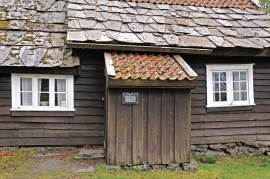
The tax collector’s farm at Sørhuglo is one of the many farms for state employees in Hordaland. According to history, “Futastovo” was built by the tax collector Gram in the second half of the 17th century. In 1943 the building was moved to Sunnhordland Folk Museum.

Einstapevoll- the farm
Einstapevoll (from einstape: “bregne” (fern)) lies on the west side of the Tittelsnes peninsula. Up to 1831 the farm was a vicarage belonging to Stord parish. The priests had leasing rights. Land rent and other fees from the farm was part of their salaries.

Espevik
220 million years ago, glowing hot molten rock masses intruded into fractures in the earth's crust in the outer parts of Hordaland. Some of these are believed to have reached the surface and formed lava flows, which since have been eroded away by wind and weather. But, most of these flows solidified into diabase sills before they got to the surface.