- Remove Cultural landscapes filter Cultural landscapes
- Remove Samnanger filter Samnanger
- Remove Voss, frå 2020 del av nye Voss herad. filter Voss, frå 2020 del av nye Voss herad.
- Remove Archaeological findings filter Archaeological findings
- Remove Sediments filter Sediments
- Remove Factories filter Factories
- Remove Austevoll filter Austevoll
- Remove Etne filter Etne

Eidsbøen
Where the school and the sports facility lie at Eidsbøen there was previously a bog surrounded by small hillocks. More than 1000 years ago this was a holy place, where the dead were buried.


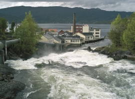
Tysse
As early as 1862 Svein L.Røsseland started a country store and lodging house at Ytre Tysse, and later on he became steamship agent and the first post office manager in Samnanger. However, the decisive change came when F.Mathiessen started A/S Samnanger Uldvarfabrik (woollen factory) in 1886.

The village of Etne
Much of the sand and gravel that the town of Etne is built on was laid down at the end of the Ice Age and is evidence of melting glaciers and roaring meltwater rivers. The uncompacted material in the big terraces leave their unmistakeable mark on the wide elongated valleys.

Stordalen
When the Etne water system was protected in 1994, preservation of the cultural landscape in Stordalen Valley was a a main objective. This is a valley with an exceptional abundance of Different types of plants and animals. In the grey alder forest in Stordalen there are more bird species than in most other places, in fact, denser than one tends to find in a tropical rainforest.


Byrkjehaugen
On the farm Bø, close to the highway between Bulken and Voss lies Byrkjehaugen, one of the largest burial mounds in West Norway. Originally it was around 50m across and 5m high, but following the excavation in 1908 and chipping off by both railway and road construction, the cross-section has shrunk to 37m and the height to 4m. All the same, it is an impressive burial monument for the passing traveller to see.

Ulvund
One of the oldest farms in Myrkdalen, Ulvund, is recognized as one of 14 areas in Hordaland having an especially valuable cultural landscape. The dirt road runs along a steep slope down toward Lake Myrkdalsvatnet. The flattest field, which today is harvested for silage, used to be an old grain field, while the slopes were old hayfields.

