- Remove Middle age filter Middle age
- Remove Maritime environments filter Maritime environments
- Remove Place filter Place
- Remove Hardanger og Voss filter Hardanger og Voss
- Remove Boat- and shipyards filter Boat- and shipyards
- Remove Conservation area filter Conservation area
- Remove Chieftains and royal lines filter Chieftains and royal lines
- Remove Hydro power filter Hydro power
- Remove Archaeological findings filter Archaeological findings


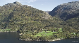
Svåsand
Down by the fjord at Svåsand, close to the main highway, there is a long row of boathouses, one of the well-preserved, older boathouse locations along the Hardanger fjord. It is the farms at Svåsand that have their boathouses here, four main farms with origins far back in time.
Torsnes
When bishop J.Neumann was on a visitation in Hardanger in 1825 he also visited Torsnes, the seat of the Galtung family. They were then in the process of pulling down the old dwelling house on the farm. As the committed observer of ancient monuments and antiquarian buildings that he was, bishop Neumann has provided us with interesting details:

Bjoreidalen
Bjoreidalen is one of the classic bird localities on Hardangervidda. It is especially known for its wading birds, with as many as 17 of the 19 wader species that nest in Hordaland.

Hæreid- archaeology
The biggest prehistoric burial site in Hordaland is situated at Hæreid. On top of the terrace expanse, inside the fine birch garden, is where they lie, the mounds and stone piles, on their own or in clusters, large and small, round and elongated – at least 350 in all.

Halne
At Halnefjorden, a few hundred metres east of Halne mountain lodge, lie the remains of two stone sheds – Halnelægeret. Some generations ago the cattle drovers stopped here in the summer; they were the cowboys of their time. But Halnelægeret already had a long history before the cattle drovers came.

Langavassmyrane
The Ruff lek on Langvassmyrane is the only known phenomenon of its kind on Hardangervidda. Every year it attracts hens from the whole plateau. The marsh is also the richest wetland in the county. This green oasis is located in a rocky moraine landscape a few hours walking distance south of Dyranut.


Granvinsvassdraget
After the ice age, Granvin Fjord reached all the way up under Skjervsfjossen waterfall. Just a thousand years later, as a result of the rising of the land after the ice melted, this whole inner part of the fjord freed itself of the sea and became Granvinsvatnet lake. In spite of this rise in elevation, this waterway is still navigable for fish: Sea trout have wandered into Granvinsvatnet in more recent times and evolved to become freshwater trout. And salmon and sea trout made the journey 13 kilometres up the Storelvi river.

Joberget
Flowering lime is one of nature's blessings: The nectar gives clear honey. The flower is used as folk medicine. From the inner bark of the lime tree one can make strong rope. Elderly folk can still tell how they got a weather report from the lime tree. If it smelled strong, it was probably going to rain. Lime often grows together with elm, ash and other tree species of the deciduous forest. Pure lime forests are rarer. Granvin has Hordaland's biggest lime forests.

