- Remove Quarns and mills filter Quarns and mills
- Remove Benthic organisms filter Benthic organisms
- Remove Nordhordland filter Nordhordland
- Remove Forestation filter Forestation
- Remove Cultural landscapes filter Cultural landscapes
- Remove Quarries filter Quarries
- Remove Fisheries filter Fisheries
- Remove Railroad filter Railroad


Stormark
Both the climate and people have been decisive in shaping the bog landscape on Fedje - a landscape that has been evolving over several thousands of years. The peat got built up layer for layer and provided income and fuel for the people of Fedje.

Bjørsvik
The industrial settlement Bjørsvik
Lure Fjord
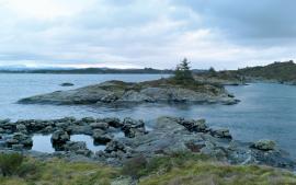
Both Lure Fjord and Lindåsosane to the inside give good living conditions for rare marine organisms: jellyfish, shellfish and fish. These include animals that migrated in after last the Ice Age, when the sea level was higher. Eventually, as the land rose, some of these populations became isolated.

Lurekalven
Lurekalven is an unpopulated island of heather moor which is a part of the wilderness belonging to the five farms on Ytre Lygra. Between the two islands there is only a small sound. As late as the 1920s, milking cows were rowed over the sound from Lygra in summer – a form of farming that was adapted to the coastal landscape.


Lygra
The heath landscape on outer Lygra, Utluro and Lurekalven will in future become part of a landscape protection area, to be maintained through traditional activities with year-round outdoor sheep, grazing and burning. The West Norwegian heath country belongs to a large North Atlantic coastal landscape stretching from the Bay of Biscay to the Lofoten islands.


