- Remove Quarns and mills filter Quarns and mills
- Remove Benthic organisms filter Benthic organisms
- Remove Nordhordland filter Nordhordland
- Remove Forestation filter Forestation
- Remove Maritime environments filter Maritime environments
- Remove Defense filter Defense
- Remove Road constructions filter Road constructions
- Remove Boats and seafaring filter Boats and seafaring

Krossøy
Furthest north in the island community Rongevær, at the entrance to Fensfjorden, lies Krossøy. Belonging to the farm are the islands of Krossøy, Husøy, Kårøy, Lyngkjerringa, Søre Kjerringa, Rotøy and Kuhovet. All of them have been inhabited. On Krossøy itself today there are four holdings. The marine use environment here is one of the best preserved along the West Norwegian coast.


Vinappen
Vinappen lies on a low hill to the very west on the island. Here you have an amazing panorama of the sea. Originally the area was grazing land for cattle, but this changed when the Germans occupied the island. Just before WWII there was a small bearing station, used by the Norwegian Coast Artillery in connection with exercises at sea.

Bjørsvik
The industrial settlement Bjørsvik

Lure Fjord
Both Lure Fjord and Lindåsosane to the inside give good living conditions for rare marine organisms: jellyfish, shellfish and fish. These include animals that migrated in after last the Ice Age, when the sea level was higher. Eventually, as the land rose, some of these populations became isolated.

Spjutøy
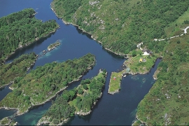
At Spjutøy and Straumsosen there are three entrances from Lurefjorden to the fjord basin inside. Right up the end of the 1800s the ferry could not reach further than to Mølna at Spjutøy. At Skallestraumen there was a bark mill driven by the powerful tidal current in the sound. Here was also a store, a bakery and a hostelry place around the middle of the 1800s.


Håøy
Håøy lies centrally in one of the main shipping lanes going into Bergen --- with Håyøsund on the south side facing Meland, and Hagelsundet facing Lindåslandet. Names like Nordfarskista and Nordfarsskorane explain things. The strategic position was important in Viking times and it has been important in our days too. The beacon on Håøy can have been built in the establishment of the coastal administration in Håkon the Good’s time, about 950 AD. The defence structure of which we say remains on Håøy Summit held a critical position during Norwegian neutrality during the First World War. The defence structure was taken down in 1957.

