- Remove Quarns and mills filter Quarns and mills
- Remove Iron age filter Iron age
- Remove Faults filter Faults
- Remove Defense filter Defense
- Remove Lindås, frå 2020 del av nye Alver kommune. filter Lindås, frå 2020 del av nye Alver kommune.
- Remove Os, frå 2020 del av nye Bjørnafjorden kommune filter Os, frå 2020 del av nye Bjørnafjorden kommune
- Remove Deciduous forests filter Deciduous forests

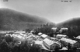
Bjørsvik
The industrial settlement Bjørsvik

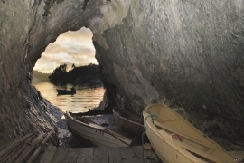
Lurekalven
Lurekalven is an unpopulated island of heather moor which is a part of the wilderness belonging to the five farms on Ytre Lygra. Between the two islands there is only a small sound. As late as the 1920s, milking cows were rowed over the sound from Lygra in summer – a form of farming that was adapted to the coastal landscape.


Seim
Sæheim (Seim) at Lygrefjord is mentioned as one of the royal farms of Harald Hårfagre. Several of the first Norwegian national kings had their seat here, and the farm became Crown Property up to the 1400s. According to the sagas, Håkon den gode is buried on the farm.

Stall
The Bergen Arcs have an unusually sharp boundary to the bedrock in the east. Geologists think that this was caused by movements in the earth's crust during the Devonian Period. Then, the Bergen Arcs on the Lindås peninsula sank a whole 10 kilometres in relation to the Precambrian basement gneisses on the east side of Fens Fjord and Aust Fjord.

Vollom
On Vollom, northwest of Seim, we find the only natural beech forest in Western Norway, which is also the most northerly of its type in the world. Beech grows also many other places in the county, but these trees are totally lacking in history compared with those of Vollomskogen Forest.
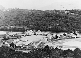
Osøyro
The coastal settlement of Os begins to take form in the middle of the 1800s. This is when craftsmen and traders begin to settle at the river delta.