- Remove Quarns and mills filter Quarns and mills
- Remove Thrust sheets filter Thrust sheets
- Remove Sunnhordland filter Sunnhordland
- Remove Avalanches and rock falls filter Avalanches and rock falls
- Remove Nordhordland filter Nordhordland
- Remove Hardanger og Voss filter Hardanger og Voss
- Remove Churches filter Churches

Bondhusdalen
The Bondhus area in Maruanger has been a magnet for tourists ever since the stream of tourists to Norway's west coast began in the middle of the 1800s. The magnificent landscape with the "ice trail" up to Bondhusvatnet Lake, the ice falls from Bondhusbreen glacier and Keisarstigen trail up to Folgefonna are still popular tourist attractions.

Fjelberg
The beautiful vicarage on the Fjelberg Island lies a few minutes walk up from the fjord, in a compact enclosure with the church south of the main building and the bishop’s residence to the north; a rare harmonic cluster.

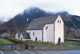
Kvinnherad Church
The stately Kvinnherad Church with its characteristic profile set out against the mighty Malmangernuten in the background, gives you a rare feeling of being present in a historic landscape as you come around Nes and face the well-kept houses at the Skåla farm. The church at Skåla is one of four “fjordungskirker” (one of four main district churches) and this farm was the centre of this coastal administration district.

Ølve- Mining
All in all there are ten known copper mines and two iron mines on the Ølve peninsula. Geologically, the nine mines on Varaldsøy Island also should be figured in. The industry began at Lilledal in 1642 wth the mining of iron ore. From Jernsmauget by Dyråsen, the iron ore was sent to the iron works in eastern Norway.

Ænes
Ænes has been one of the prosperous farms at the Mauranger Fjord in medieval times. At the time of Harald Gilles, around 1130, we hear of GAUT at Ænes. The noble families around the Hardanger Fjord were prominent in the political sphere from early on, and it is obvious that the fine and openly situated farm at Ænes was also a good place for a Church.

Hereiane
At Hereiane on warm summer days one you can walk barefoot up the hill from the fjord all the way up to 400 metres elevation. The naked, furrowed bedrock often causes travellers who see it from the north side of the fjord to wonder. Why does it look like this, and why is there so little that grows here? It is a long way to the heavy metal industry in Ålvik and Odda, and there hasn’t been a forest fire in modern times.


Lussand- geology
Hardangerfjorden kløyver Hordaland i to. Den etter måten rettlinja fjorden skjer seg liksom på skeive inn i landet. Ikkje som Sognefjorden og Nordfjord – dei krokar og buktar seg innover meir eller mindre vinkelrett på kysten. Hardangerfjordens utforming har røter 400 millionar år tilbake i tida, då den veike sona i fjellet, der isen seinare tok grådig for seg, vart danna. Denne sona stig på land ved Lussand.

Storegraven
The first mention of Granvin church in written sources is in 1306, but the church location must be far older than this. The farm Storegraven is centrally situated at Granvinsvatnet, by the important traffic artery between Hardanger and Voss, where the road takes off to Ulvik.

