- Remove Quarns and mills filter Quarns and mills
- Remove Bergen filter Bergen
- Remove Quarries filter Quarries
- Remove Wetland filter Wetland
- Remove Large landforms filter Large landforms
- Remove Chieftains and royal lines filter Chieftains and royal lines

Åsane
Most associate Åsane with ridges, naturally enough (the Norwegian word for "ridge" is "Ås"). A lesser noticed trait in the landscape are the unusual flat areas that lie between the ridges. The Dalselva River, which was channeled at the end of the 1950s, runs down only 2.5 metres from Lake Langavatnet by Vågsbotn to Flatevad, where it goes over into rapids by Fossekleiva. The layers of gneiss stand nearly vertically, and the mountain surface is so even that one might think it had been planed with a planer.

Årstad
Alrekstad (later Årstad) is the birthplace of Bergen. The estate was an estate for Harald Hårfagre and several of his descendants: Eirik Blodøks, Håkon den gode og Olav Tryggvason. These first kings moved with their courts and guardsmen from estate to estate. From these estates the king ruled the country.


Sandviksfjellet
On Sandviksfjellet there are old boulders that have been made into mountains. The stones have been stretched out or squeezed together between huge slabs of rock, during slow, but powerfulprocesses of transport. This conglomerate shows, in quite a special way, the enormous powers that were active during the collision between Norway and Greenland over 400 million years ago.

Sandviken
Close to the tunnel opening at Amalie Skrams vei in Ssandviken, there is a cultural monument of European dimensions; a rope making works that produced rope and fishing tackle for West and North Norway.

Reppadalen
The unusual bog landscape, with enormous peat deposits surrounded by steep mountainsides, makes Reppadalen in Arna an exciting, but little visited tour destination for most of Bergen's inhabitants. Those who live in Arna, however, know to make the most of its beautiful natural splendour.
Rambjøra
In Sanddalen and Helldalsåsen the building of houses has increased dramatically. Where there eariery was grazing land, hundreds of families now live. Not far away, lies Rambjøra as an oasis in the built up area.


Kalandsvika
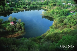
There is little to say about the opportunity for surveying from the bird observation tower in Kalandsvika: 155 different bird species have been sighted in the Kalands water shed. Take your binoculars and visit the tower in late spring - early summer or during the winter half of the year. If you are lucky, you might get to see a rare bird species.

