- Remove Quarns and mills filter Quarns and mills
- Remove Midthordland filter Midthordland
- Remove Pollution and environment filter Pollution and environment
- Remove Defense filter Defense
- Remove Place filter Place
- Remove Cultural landscapes filter Cultural landscapes
- Remove Late glacial filter Late glacial
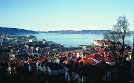
Byfjorden
Swimming and fishing is fully possible in Byfjorden (By Fjord). The water is of good quality most places, after considerable resources have been used in past years for clean-up. But, past sins still lie in the mud on the sea bottom. Fish that live in direct contact with the bottom sludge should not be eaten.

Nordåsvatnet
The Post-war Era came to Fana with its population growth and modern sanitary equipment. This had nearly catastrophic consequences for Nordåsvatnet as a recreational area. After the runoff water got re-directed to deeper water, and later also to the fjord outside, Lake Nordås won back both its swimming guests and its sports fishermen.

Sandviken
Close to the tunnel opening at Amalie Skrams vei in Ssandviken, there is a cultural monument of European dimensions; a rope making works that produced rope and fishing tackle for West and North Norway.


Skjelbreid
On the east side of Lake Skjelbreidvatnet, clearly visible along the road from Eikelandsosen, we notice a farm on a terrace above a grassy hill. The hill has the form of a broad shield; Skjelbreid (" Broad Shield") is the name of the farm.

Vinnesleira
Bays that are shallow far out into the sea, with fine sand and clay, are rare in Hordaland. Where they are found, the reason is usually that the edge of the glacier made smaller advances or stopovers when it calved back at the end of the last Ice Age. This is what happened at Vinnesleira.

Herdla – glacial deposits
The shift in the landscape is striking between the barren craggy moors north on Askøy and the green fields of Herdla, which has the county's biggest farm. The majority of Herdla, such as the island appears today, is a gift from the glacier: The glacier that advanced here over 12,000 years ago stopped at the northern tip of Askøy and took its time building up the moraine on Herdla. Since then, Herdla has been under continual transformation. The re-organisation of the loose sediment deposits continues today.

