- Remove Quarns and mills filter Quarns and mills
- Remove Midthordland filter Midthordland
- Remove Lakes, rivers and river networks filter Lakes, rivers and river networks
- Remove Pollution and environment filter Pollution and environment
- Remove Cultural landscapes filter Cultural landscapes
- Remove Large landforms filter Large landforms

Sandviken
Close to the tunnel opening at Amalie Skrams vei in Ssandviken, there is a cultural monument of European dimensions; a rope making works that produced rope and fishing tackle for West and North Norway.
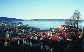
Byfjorden
Swimming and fishing is fully possible in Byfjorden (By Fjord). The water is of good quality most places, after considerable resources have been used in past years for clean-up. But, past sins still lie in the mud on the sea bottom. Fish that live in direct contact with the bottom sludge should not be eaten.

Nordåsvatnet
The Post-war Era came to Fana with its population growth and modern sanitary equipment. This had nearly catastrophic consequences for Nordåsvatnet as a recreational area. After the runoff water got re-directed to deeper water, and later also to the fjord outside, Lake Nordås won back both its swimming guests and its sports fishermen.


Åsane
Most associate Åsane with ridges, naturally enough (the Norwegian word for "ridge" is "Ås"). A lesser noticed trait in the landscape are the unusual flat areas that lie between the ridges. The Dalselva River, which was channeled at the end of the 1950s, runs down only 2.5 metres from Lake Langavatnet by Vågsbotn to Flatevad, where it goes over into rapids by Fossekleiva. The layers of gneiss stand nearly vertically, and the mountain surface is so even that one might think it had been planed with a planer.


Skogseidvatnet
Lake Skogseidvatnet is the most famous fishing lake in Hordaland, with good stocks of both char and trout. There is fishing here throughout the year: with a net in the autumn, through the ice in winter, and with a fishing rod in the summer.

