- Remove Smallholdings filter Smallholdings
- Remove Maritime environments filter Maritime environments
- Remove Churches filter Churches
- Remove Eidfjord filter Eidfjord
- Remove Glaciers filter Glaciers
- Remove Radøy, frå 2020 del av nye Alver kommune. filter Radøy, frå 2020 del av nye Alver kommune.
- Remove Etne filter Etne
- Remove Meland, frå 2020 del av nye Alver kommune. filter Meland, frå 2020 del av nye Alver kommune.
- Remove Chieftains and royal lines filter Chieftains and royal lines

Simadalen
On the 10th of August, 1937, over half of the agricultural land in Simadalen was submerged by the river. The damage to roads and houses was also catastrophic. This was the most destructive flood ever recorded in Hordaland.

Håøy
Håøy lies centrally in one of the main shipping lanes going into Bergen --- with Håyøsund on the south side facing Meland, and Hagelsundet facing Lindåslandet. Names like Nordfarskista and Nordfarsskorane explain things. The strategic position was important in Viking times and it has been important in our days too. The beacon on Håøy can have been built in the establishment of the coastal administration in Håkon the Good’s time, about 950 AD. The defence structure of which we say remains on Håøy Summit held a critical position during Norwegian neutrality during the First World War. The defence structure was taken down in 1957.

Holmeknappen
If you come by sea to Bergen and come up the Herdle Fjord, the yellow ochre marine shed at Holmeknappen is a well known landmark to starboard as you come close to the little shore settlement. In olden days Holmenknappen served important functions as a centre for a wide hinterland of the surrounding farms, warehouse, landing point, country store and later a steamer quay, a hotel (1896) and a dairy (1909). But today Holmeknappen is no longer a focal point. Transport and commercial routes have changed the old pattern

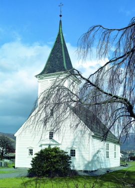

Grindheim church
The first church at Grindheim was a stave church with a free-standing steeple. The church was first mentioned in 1326, but was probably built long before this time.

Støle
High above the sea and the beach flats, on one of the wide terraces shaped by the sea and the ice, lies the farm Støle (Stødle). The Old Norse name of Studla is derived from studill “support, shelf”. As far back as Viking times Støle has been a chieftain’s farm, a good farm on the plains formed by the moraine masses.

Støle church
The stone church at Støle may have been built around 1160 probably as a private chapel for the mighty Stødle clan. It is likely that it was Erling Skakke, the king’s representative and father of king Magnus Erlingsson, who built the church.


Mosnes
The permanently-protected Mosneselva River, with its meltwater from Folgefonna, runs out into Åkra Fjord by the roadless and uninhabited Mosnes. Those who once lived here were forced to surrender to the ravages of Nature. In the autumn of 1962 there was a flood so great that the people were driven from their farms.

