- Remove Smallholdings filter Smallholdings
- Remove Music filter Music
- Remove Os, frå 2020 del av nye Bjørnafjorden kommune filter Os, frå 2020 del av nye Bjørnafjorden kommune
- Remove Rock carvings filter Rock carvings
- Remove Railroad filter Railroad
- Remove Sediments filter Sediments
- Remove Coniferous forests filter Coniferous forests
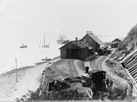
- Remove Etne filter Etne

The village of Etne
Much of the sand and gravel that the town of Etne is built on was laid down at the end of the Ice Age and is evidence of melting glaciers and roaring meltwater rivers. The uncompacted material in the big terraces leave their unmistakeable mark on the wide elongated valleys.

Helgaberget
Helgaberget – the holy hill – is a little rocky crag which thrusts itself a few metres above the terraced surface of Støle. The surface of the rock is strewn with figures inscribed in the rock and it was, as far as one can judge, a cult centre in the Bronze Ages. The name could indicate that the tradition of holiness can have lasted for almost 3,000 years.


Grødalshaug
At the bottom of Vargavågen on Halhjem lies Grødalshaug, a 30 metres high rocky outcrop between the bay and a moist valley cleft. On the south side of the rock is a steep rock cliff facing the valley, the bog and the stream. On this rock face we find rock carvings from the Bronze Age.


Skånevik- moraine
In Skånevik there are marks left from the ice edge that advanced during the thousand-year cold spell (Younger Dryas) that marked the end of the Ice Age roughly 11 500 years ago. The glacier first proceeded out into Åkra Fjordand and around Vannes and thereafter sent an arm in toward Skånevik. Here, the glacier lay down an end moraine up against the mountainside.


