- Remove Smallholdings filter Smallholdings
- Remove Tourism filter Tourism
- Remove Railroad filter Railroad
- Remove Middle age filter Middle age
- Remove Late glacial filter Late glacial
- Remove Vegetation history filter Vegetation history
- Remove Modalen filter Modalen
- Remove Ullensvang, frå 2020 del av nye Ullensvang kommune. filter Ullensvang, frå 2020 del av nye Ullensvang kommune.

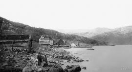
Mostraumen
Until 1743 the people from Modal had to wait for a flood in MOSTRAUMEN before they could draw their boats up the river current, and then row back across Lake Movatnet. But, that year the flood opened a free passageway all the way to Mo. Hordaland had gained a new tidal waterway.

Nedre Helland- Sand Quarries
The three spades in the municipal coat of arms for Modalen are sand spades. Sand quarrying has brought income and employment. As much as 70,000-80,0000 tonnes of sand and gravel left the municipality each year since the turn of the millennium, to be used as cementing sand. Why is Modalen endowed with so much sand?

Nottveit
In one of the frame-built haysheds at Nottveit, at holding No. 3, we discover that several of the staves have a medieval look, with large dimensions and carefully rounded edges. According to tradition, it was the farms Nottveit and Mostraumen that supplied the timber for the stave church at Mo, and it is not unlikely that these farms received the old timber in return when the new church was erected there in 1593.

Otterstadstølen
Otterstadstølen lies in an idyllic grassy plain surrounded by rich forest, but also with high mountains close by. The mountainsides are steep and typical of this part of the county. The same cannot be said about the forest. This spruce forest has been able to develop freely for hundreds of years. Otherwise in the county, only Voss has spruce forest.

Aga
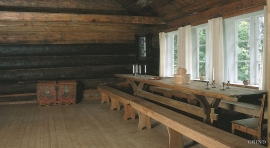
The grand farm Aga on the west side of Sørfjorden, came under protection in 1937, when the agricultural reform threatened to disperse the old clustered settlement. “Lagmannsstova”, named after the “lagmann” (law speaker) Sigurd Brynjulfsson, was already protected in 1924; one of the authentic profane wooden buildings from the Middle Ages still standing. All the same it is the farmyard itself that is the key cultural monument.
Jåstad
The farm Jåstad, situated a few kilometres north of Agatunet, must have been a grand farm in medieval times. Torolf on Jåstad is mentioned as arbitration moderator in 1293, and in the vaulted corridor at Lyse Kloster Sigurd, farmer at Jåstad, and his wife Sigrid – the king’s kinswoman - are buried.

Kinsarvik
Kinsarvik has probably been a centre for the inner Hardanger districts back in prehistory. History tells us that in medieval times there was a marketing place, a “kaupang”, here; a connecting point in the communications between east and west. There were supposedly around 300 residents here but the place was likely wiped out in a great fire.

Utne
When sergeant Peder Larsen Børsem from Strandebarm was “demobilised” in 1721, following the large Nordic War, he married the Bergen lady Elisabeth Schrøder and settled as innkeeper at Utne with a letter of privilege from the county governor dated 29 October 1722.

