- Remove Smallholdings filter Smallholdings
- Remove Vernacular arts filter Vernacular arts
- Remove Bronze age filter Bronze age
- Remove Faults filter Faults
- Remove Museum filter Museum
- Remove Landscape filter Landscape
- Remove Industry, Energy and Natural Resources filter Industry, Energy and Natural Resources

Alvøen
Alvøen is one of the oldest industrial places in Norway. As early as the 1620s a gunpowder mill was built here. The place itself was well situated for industrial activity, lying only 100 m from the waterfall, which provided power for the mill, and a good harbour wherefrom the products were shipped. The success of the gun-powder mill varied in the 1600s and 1700s, but what made Alvøen best known was its paper production.

Valestrandsfossen- tanning industry
Valestrand became a centre for the tanning industry in Osterøy; one of the old crafts that has developed into a local industry with many places of work. From the 1870s ever more ventures were started. Many of the large sea houses we see today around the bay have been places for tanning and leather enterprises.
Litlabø
The first finds of pyrite at Litlabø in Stord came to light in 1864. Forty years later sulphuric ore was mined from an open mine. From 1874 to 1880 it was used for dynamite production. That came to a sudden end when the factory exploded and three people died.
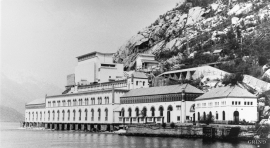
Tyssedal
Today Tyssedal appears like a classical industrial community, a picture of modern Norway from the turn of the former century until today. A/S Tyssefaldene was established in 1906, and on 1 May 1908 Tyssedal power station was put into operation. The work on the first stage of the facility was completed in a short time, with a work force of 500 men. They built water tunnels, regulation reservoirs, power station, penstocks, harbour, cableways, office buildings, houses and 6 km of power lines in the wild mountains above Odda to provide the new melting plant with power.


Haganes
The gneiss landscape west and north of Bergen viewed in profile can remind us of a saw blade of the kind that has long, slanted sides that get broken off shorter transverse sides. It has taken several hundred million years to file this saw blade, an enduring interplay between various geological processes.


Fitjarøyane
If we study the group of islands south of Selbjørns Fjord from the air or on a sea map, we will notice that many of the islands are elongated and lie systematically in rows. The islands are divided by long sounds, for example Trollosen, Nuleia and Hjelmosen, which are oriented in a south-southeast to north-northwesterly direction.

Krokavatnet
On Sunday the 29th of January, 1989, at 17:38 o'clock, Etna shook. The earthquake, with its epicentre ca. 9 kilometres south of Etne centre, had a strength of 4.2 on the Richters scale. This could be felt over large parts of West Land, especially in the areas around Åkra, Etne, Hardanger Fjord and Sauda Fjord. The earthquake was the largest that has ever been measured in Hordaland.

