- Remove Smallholdings filter Smallholdings
- Remove Basement rocks filter Basement rocks
- Remove Hardanger og Voss filter Hardanger og Voss
- Remove Museum filter Museum
- Remove Large landforms filter Large landforms
- Remove Aristocracy and civil servants filter Aristocracy and civil servants


Måbødalen- geology
The old pack road had 1500 steps, where cars today gas through the mountain. The time of this hard work is over, and of getting used to the steep terrain, as well; only the view from the top is much the same as before. Vøringsfossen in summer is one of Western Norway’s biggest natural wonders. It marks the transition between the older, open part of the Sysendalen valley and the younger, narrow and winding valley of Måbødalen.


Kvalvikane
In Ålvik quartz has long been used to produce ferro-silicon. The quartz was collected from the other side of the fjord, from the mountainside above Kvalvikane.

Hårteigen
Hårteigen, «the grey signpost», as the name suggests, is a landmark for mountain hikers on the western plateau. The piece of mountain is also a monument for the mighty rock layers that once covered the entire plateau.

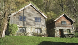
Ullensvang vicarage
Well over 200 years ago, the priest Niels Hertzberg started making climate observations at the vicarage at Lofthus in Ullensvang. Hertzberg was active and ahead of his time in many fields, and had a great interest in natural science. Temperature and pressure were measured daily at the vicarage - often several times a day - with homemade instruments. The meteorological measurements started in December of 1797, and were carried out continuously until 1840, the year before he died.

Tokagjelet
There is a sharp transition between the wide valley at Kvamskogen and the narrow Tokagjelet. The transition is no less dramatic when we come out of the crooked tunnels far down in the canyon, and the open Steinsdalen valley spreads out before us. The canyon both separates and joins together different epochs in western Norway's history.

Lussand- geology
Hardangerfjorden kløyver Hordaland i to. Den etter måten rettlinja fjorden skjer seg liksom på skeive inn i landet. Ikkje som Sognefjorden og Nordfjord – dei krokar og buktar seg innover meir eller mindre vinkelrett på kysten. Hardangerfjordens utforming har røter 400 millionar år tilbake i tida, då den veike sona i fjellet, der isen seinare tok grådig for seg, vart danna. Denne sona stig på land ved Lussand.

