- Remove Smallholdings filter Smallholdings
- Remove Waterfalls filter Waterfalls
- Remove Large landforms filter Large landforms
- Remove Vernacular arts filter Vernacular arts
- Remove Wetland filter Wetland

Ulvenvatnet
Lake Ulvenvatnet is thought to be the most species rich wetlands in the municipality. Despite this, the area is not protected, nor is it likely ever to be.

Haugsdalen
Early in the 1900s there were much larger salt water deltas in Hordaland. But, essentially all of the larger river deltas got filled in and regulated for use in industry during the last century. Now, there is only Haugsdals delta left.

Granvinsvassdraget
After the ice age, Granvin Fjord reached all the way up under Skjervsfjossen waterfall. Just a thousand years later, as a result of the rising of the land after the ice melted, this whole inner part of the fjord freed itself of the sea and became Granvinsvatnet lake. In spite of this rise in elevation, this waterway is still navigable for fish: Sea trout have wandered into Granvinsvatnet in more recent times and evolved to become freshwater trout. And salmon and sea trout made the journey 13 kilometres up the Storelvi river.
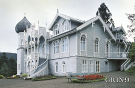
Lysøen
Lysøen, this fairytale castle with its Russian-inspired onion dome on the corner turret, stands as a reminder of the diversity of the period called Historicism and a monument to a versatile artist; a key figure in the Norwegian National Romanticism.
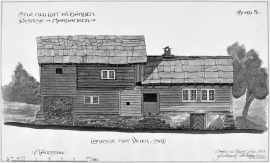
Huse
The farm Huse is situated on a broad terrace in the valley above the church and the commons ground in Kinsarvik. Huse is one of the largest farms in Kinsarvik. The house from the Middle Ages, still standing at Huse today, probably from the middle of 1200, is joined on to a house in the Swiss style from around 1890. This house, with a smoke-vent in the roof, bears witness of a grand old farm and of the chieftain’s power in early medieval times.

Åsane
Most associate Åsane with ridges, naturally enough (the Norwegian word for "ridge" is "Ås"). A lesser noticed trait in the landscape are the unusual flat areas that lie between the ridges. The Dalselva River, which was channeled at the end of the 1950s, runs down only 2.5 metres from Lake Langavatnet by Vågsbotn to Flatevad, where it goes over into rapids by Fossekleiva. The layers of gneiss stand nearly vertically, and the mountain surface is so even that one might think it had been planed with a planer.

Reppadalen
The unusual bog landscape, with enormous peat deposits surrounded by steep mountainsides, makes Reppadalen in Arna an exciting, but little visited tour destination for most of Bergen's inhabitants. Those who live in Arna, however, know to make the most of its beautiful natural splendour.


Sandviksfjellet
On Sandviksfjellet there are old boulders that have been made into mountains. The stones have been stretched out or squeezed together between huge slabs of rock, during slow, but powerfulprocesses of transport. This conglomerate shows, in quite a special way, the enormous powers that were active during the collision between Norway and Greenland over 400 million years ago.

