- Remove Boat- and shipyards filter Boat- and shipyards
- Remove Faults filter Faults
- Remove Coniferous forests filter Coniferous forests
- Remove Maritime environments filter Maritime environments
- Remove Museum filter Museum
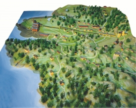
- Remove Sunnhordland filter Sunnhordland


Fitjarøyane
If we study the group of islands south of Selbjørns Fjord from the air or on a sea map, we will notice that many of the islands are elongated and lie systematically in rows. The islands are divided by long sounds, for example Trollosen, Nuleia and Hjelmosen, which are oriented in a south-southeast to north-northwesterly direction.

Hisøya
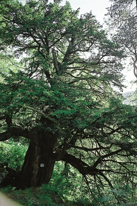
"I am going to prove to you that I am right". That is what the idealist and county doctor Christian Heitmann is supposed to have said in the early 1890s. He sat together with the parish priest, Kullmann, at Heitmann's home in Stord and discussed whether the islands in western Norway could have been forested or not. The priest thought that the area was too barren and weather-beaten for forest to have been able to grow so far out in the sea. But, Heitmann was sure he was right. He challenged the scepticism and set off to work.

Hopsfjellet
On June 2nd, 1992, a big forest fire broke out in Sveio. The fire started southeast of Hopsfjellet. In a strong wind the flames spread quickly northward. Houses on the other side of the highway were threatened, but escaped unscathed. The burned area, which is easily visible about a 5 minute's drive south from the tunnel at the triple- junction, was made into a nature reserve in 1998. The intention was to ensure that the re-establishment of plant- and animal life would take place without disturbance.

Krokavatnet
On Sunday the 29th of January, 1989, at 17:38 o'clock, Etna shook. The earthquake, with its epicentre ca. 9 kilometres south of Etne centre, had a strength of 4.2 on the Richters scale. This could be felt over large parts of West Land, especially in the areas around Åkra, Etne, Hardanger Fjord and Sauda Fjord. The earthquake was the largest that has ever been measured in Hordaland.

Litlabø
The first finds of pyrite at Litlabø in Stord came to light in 1864. Forty years later sulphuric ore was mined from an open mine. From 1874 to 1880 it was used for dynamite production. That came to a sudden end when the factory exploded and three people died.

Rosendal Barony
The Barony of Rosendal lies in the grounds of the old noble estate of Hatteberg, on the north side of the Hatteberg river, around one kilometre up from the sea. The three noble estates Seim, Mel and Hatteberg constituted the core of the large estate taken over by Ludvig Rosenkrantz in 1662, after he was married to Karen Mowat in 1658.

