- Remove Small landforms filter Small landforms
- Remove Middle age filter Middle age
- Remove Eidfjord filter Eidfjord
- Remove Lakes, rivers and river networks filter Lakes, rivers and river networks
- Remove Wetland filter Wetland
- Remove Austrheim filter Austrheim
- Remove Kvam filter Kvam
- Remove Trading posts and guesthouses filter Trading posts and guesthouses

Halne
At Halnefjorden, a few hundred metres east of Halne mountain lodge, lie the remains of two stone sheds – Halnelægeret. Some generations ago the cattle drovers stopped here in the summer; they were the cowboys of their time. But Halnelægeret already had a long history before the cattle drovers came.

Heggjagarden
The transport exchange on the farm Vik in Eidfjord was an important part of the communication network in older times. This is where people secured transport by boat out in the fjord, those travelling across the mountain from east and down into Måbødalen. The transport exchange was situated at “Wiige grund”. Today the highway cuts through the farmyard; the main farmhouse from the 1800s lies on the upper side of the road, the large sea-house, with a bakery in former times, lies close to the fjord.

Krækkjavassdraget
Few other animal species on Hardangervidda have been as much the focus of scientific research as the spotted trout. The spotted trout is considered to be a genetic variant of brown trout. It lives in parts of the Krækkjav water system. Otherwise, on a world scale, this species is only found in a small area in Kaukasus, and possibly also in a lake in Rondane.

Langavassmyrane
The Ruff lek on Langvassmyrane is the only known phenomenon of its kind on Hardangervidda. Every year it attracts hens from the whole plateau. The marsh is also the richest wetland in the county. This green oasis is located in a rocky moraine landscape a few hours walking distance south of Dyranut.

Simadalen
On the 10th of August, 1937, over half of the agricultural land in Simadalen was submerged by the river. The damage to roads and houses was also catastrophic. This was the most destructive flood ever recorded in Hordaland.
Kjelstraumen
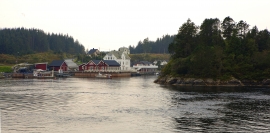
If you take the sea route north you have several options. The various routes have been dealt with in history, and through the Middle Ages the traffic increased as well as the trading with Nordland in fish and herring, feather and down. One of the central routes passes through Kjelstraumen, in the sound between Ulvøy and Bakkøy. This has been a place for a guesthouse since 1610, with Royal Letter of Privilege, part of the large network of trading post and guesthouse locations along the coast.


Leirvågen
A marsh is a grassy meadow that is strongly influenced by salt from the sea. This type of nature is abundant in Denmark, among other places. The flatlands along the river that run out by Leirvågen, are the municipalities' largest marsh. At spring tide, these flatlands are flooded underwater for several hundred metres in over land.


Bru
Bruosen is one of the few river harbours in the county. As landing place for the churchgoers, this place and the boatshed environment follow a tradition that goes back to the Middle Ages, but the country store of today is much younger.

