- Remove Small landforms filter Small landforms
- Remove Middle age filter Middle age
- Remove Eidfjord filter Eidfjord
- Remove Wetland filter Wetland
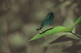
- Remove Fish filter Fish
- Remove Os, frå 2020 del av nye Bjørnafjorden kommune filter Os, frå 2020 del av nye Bjørnafjorden kommune
- Remove Radøy, frå 2020 del av nye Alver kommune. filter Radøy, frå 2020 del av nye Alver kommune.
- Remove Bømlo filter Bømlo

Langavassmyrane
The Ruff lek on Langvassmyrane is the only known phenomenon of its kind on Hardangervidda. Every year it attracts hens from the whole plateau. The marsh is also the richest wetland in the county. This green oasis is located in a rocky moraine landscape a few hours walking distance south of Dyranut.

Toska
The peat bogs on Toska have been mined for peat since 1946, when the island got electricity. In this treeless coastal landscape, peat was the most important source of energy, and this took quite a toll on the bogs.

Myking
Between Lake Kvalheimsvatnet and Lake Mykingsvatnet, north of Grindheim, we find one of the biggest continuous lowland bogs in Hordaland. It is 500-600 metres across and a whole 2 kilometres long. Locally, the bog is called "Havet" .
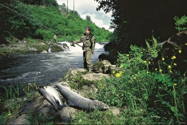
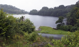
Oselva
Oselvo is the biggest waterway on the Bergen peninsula, with sources in Gullfjellet and Sveningen. There is a fall of only 60 metres along the entire stretch from Samdalsvatnet Lake to the sandbank in Fusafjorden. It is rare to see a river like this in western Norway. There is salmon along this entire section of the Oselvo river.

Lysekloster- The monks and nature
Lysekloster was the largest agricultural property in the country when it was phased out during the Reformation in 1537. In its prime this cloister encompassed two-thirds of all the farms in Os. The monks introduced and cultivated new plant species and it was probably they who stocked the waters with fish not indigenous to the area. This legacy from the Middle Ages has left a lasting mark.