- Remove Small landforms filter Small landforms
- Remove Tourism filter Tourism
- Remove Farm sites filter Farm sites
- Remove Large landforms filter Large landforms
- Remove Bronze age filter Bronze age
- Remove Middle age filter Middle age
- Remove Chieftains and royal lines filter Chieftains and royal lines


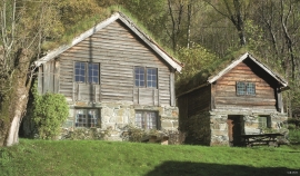
Støle
High above the sea and the beach flats, on one of the wide terraces shaped by the sea and the ice, lies the farm Støle (Stødle). The Old Norse name of Studla is derived from studill “support, shelf”. As far back as Viking times Støle has been a chieftain’s farm, a good farm on the plains formed by the moraine masses.

Kinsarvik
Kinsarvik has probably been a centre for the inner Hardanger districts back in prehistory. History tells us that in medieval times there was a marketing place, a “kaupang”, here; a connecting point in the communications between east and west. There were supposedly around 300 residents here but the place was likely wiped out in a great fire.
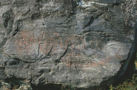

Bakko
Everyone knows the famous painting by Tidemand & Gude “Brudeferden i Hardanger” (The Wedding Party in Hardanger) one of the great icons in the National Gallery. Some have, in a humorous lack of respect for this masterpiece linked the concept of “bride’s passage” to another pictorial presentation in Hardanger. This is found on the farm Bakko in Herand, carved in the rock by an unknown artist around 3,000 years ago.


