- Remove Small landforms filter Small landforms
- Remove Boat- and shipyards filter Boat- and shipyards
- Remove Basement rocks filter Basement rocks
- Remove Nordhordland filter Nordhordland
- Remove Lighthouses filter Lighthouses
- Remove Sediments filter Sediments
- Remove Mammals filter Mammals
- Remove Faults filter Faults
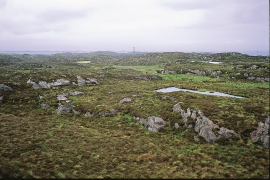
Fedje bog
The wild rabbit is really native to Northwest Africa, but the Ancient Romans introduced them to large parts of Europe. Not to Norway, rightly enough: the population on Fedje originated from 3-4 pairs that were brought here from the Shetland Isles in 1875, making this their first residence in the country.

Hellisøy
Hellisøy lighthouse was lit for the first time in 1855. The characteristic red cast-iron tower with two white belts is 33m high and a light height of 46m above high tide.

Holmengrå
Holmengrå is the only place in Hordaland where we find traces of the abrasion that is supposed to have transformed Western Norway from a Himalaya-like high mountain landscape during the earth's Paleozoic Era, to a flat lowlands terrain during the Mezosoic Era. Just 400 million years ago, large and small stones plummeted down from the high mountains. Some of these stones became incorporated into the conglomerate bedrock on Holmengrå.


Stall
The Bergen Arcs have an unusually sharp boundary to the bedrock in the east. Geologists think that this was caused by movements in the earth's crust during the Devonian Period. Then, the Bergen Arcs on the Lindås peninsula sank a whole 10 kilometres in relation to the Precambrian basement gneisses on the east side of Fens Fjord and Aust Fjord.


Mostraumen
Until 1743 the people from Modal had to wait for a flood in MOSTRAUMEN before they could draw their boats up the river current, and then row back across Lake Movatnet. But, that year the flood opened a free passageway all the way to Mo. Hordaland had gained a new tidal waterway.

Nedre Helland- Sand Quarries
The three spades in the municipal coat of arms for Modalen are sand spades. Sand quarrying has brought income and employment. As much as 70,000-80,0000 tonnes of sand and gravel left the municipality each year since the turn of the millennium, to be used as cementing sand. Why is Modalen endowed with so much sand?

Eksingedalen- landscape
Eksingedalen alternates between wide, flat flood plains with good farmland, and narrow passages with waterfalls where the roads cling to the mountainsides. The alternations in the landscape are a result of the sculpturing work by glaciers over several ice ages, and the deposition of the glacial river deposits when the last glacier finally melted back.


