- Remove Small landforms filter Small landforms
- Remove Boat- and shipyards filter Boat- and shipyards
- Remove Basement rocks filter Basement rocks
- Remove Nordhordland filter Nordhordland
- Remove Large landforms filter Large landforms
- Remove Museum filter Museum
- Remove Currents and tides filter Currents and tides
- Remove Metamorphic rocks filter Metamorphic rocks
- Remove Factories filter Factories
- Remove Wetland filter Wetland

Leirvågen
A marsh is a grassy meadow that is strongly influenced by salt from the sea. This type of nature is abundant in Denmark, among other places. The flatlands along the river that run out by Leirvågen, are the municipalities' largest marsh. At spring tide, these flatlands are flooded underwater for several hundred metres in over land.

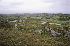
Fedje bog
The wild rabbit is really native to Northwest Africa, but the Ancient Romans introduced them to large parts of Europe. Not to Norway, rightly enough: the population on Fedje originated from 3-4 pairs that were brought here from the Shetland Isles in 1875, making this their first residence in the country.
Stormark
Both the climate and people have been decisive in shaping the bog landscape on Fedje - a landscape that has been evolving over several thousands of years. The peat got built up layer for layer and provided income and fuel for the people of Fedje.

Bjørsvik
The industrial settlement Bjørsvik
Fossevatna
Fossevatna, some few kilometres north of Alversund, is one of the finest wetland areas in Lindås. Especially the birdlife has made this place well known. Throughout the year, one can make exciting bird discoveries. But, if you want to hear the flight games skal høre med fagredaktør Stein Byrkjeland of the Snipe, you should come here on a spring or summer evening.

Dyrdal
If you journey along Austfjorden, you at the same time turn the pages of time back through Ice Age history. The landforms show how the landscape has developed gradually as the glaciers have grown - and melted again - in several episodes: from small cirques, we see innermost at Dyrdal, to larger fjords, like at Mas fjord further out.

Haugsdalen
Early in the 1900s there were much larger salt water deltas in Hordaland. But, essentially all of the larger river deltas got filled in and regulated for use in industry during the last century. Now, there is only Haugsdals delta left.

Eldsfjellet
The eclogites in western Norway were formed when Precambrian basement rocks were squeezed and pressed down under great pressure deep under the Caledonian mountain chain. The process may well have triggered some of the deepest earthquakes the world has ever known. The clearest traces of this drama are found in and around Mt. Eldsfjellet, in peaceful Meland.


