- Remove Small landforms filter Small landforms
- Remove Eidfjord filter Eidfjord
- Remove Fusa, frå 2020 ein del av nye Bjørnafjorden kommune filter Fusa, frå 2020 ein del av nye Bjørnafjorden kommune
- Remove Civil servant dwellings and manors filter Civil servant dwellings and manors
- Remove Farm sites filter Farm sites
- Remove Vaksdal filter Vaksdal
- Remove Fitjar filter Fitjar

Eikelandsosen
"So many and such big potholes as are found at Eikelandsosen, we don't see other places in western Norway, and as beautifully polished as the mountainside is along the river up to Koldal , one would look a long time to see anywhere else. There is much to dazzle a geologist's eyes. If only these features could bring others the same joy!"
Engevik
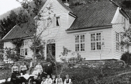
Halfway into the Sævareidfjord lies the officer’s farm Engevik. In the beginning of the 1700s the farm was in part estate of the crown and owned by farmers. In 1724 lieutenant-colonel Christian Wilhelm Segelcke settled there and erected a new farm around an imposing main building a little way north of the old farm site.

Gullbrå
From written sources we know that the farm Gullbrå was in use early in the 1600s. The Apostolic church in Bergen owned land here that it rented out, but even early in the 1600s some of the land was in private ownership. Eksingedalen then belonged to Modalen parish, which was under Hamre parish. In 1723 the Apostolic church still had properties here, and Ivar and Lars were farmers.


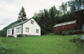
Hjølmo
In the steep hillside in Hjølmodalen, a small side valley from Øvre Eidfjord (Upper Eidfjord), which has been a key entrance to the Hardanger Plateau, the hamlet of old farmhouses still lie clustered together. The yard is empty today, some of the houses are used in the summer, but the grass grows round all the corners.

Kjeåsen
High up above the fjord, at a height of 600m lie the two holdings at Kjeåsen. Today you can drive there by car, through a new tunnel that the power engineers in Sima have drilled. Until 1974 the only road went up the steep hillside, along iron bolted ladders across dizzying rocks – a road for the strong at heart.


Måbø
Måbø is the uppermost farm in Måbødalen. This narrow and steep mountain valley has been one of the routes from the fjord communities up to the mountain plateau from times immemorial. We are not certain of the meaning of the name Måbø. Perhaps it has its origin in an Old Norse male name Mávi, from the name for seagull, már. The last syllable “bø” means farm. Today Måbø gives us a compact close-up of the subsistence economy: the small farm with the clearance piles, stone walls and a lane that guided the animals into the yard, at the foot of the great mountain expanse.


