- Remove Small landforms filter Small landforms
- Remove Kvinnherad filter Kvinnherad
- Remove Maritime environments filter Maritime environments
- Remove Monastery filter Monastery
- Remove Fitjar filter Fitjar
- Remove Avalanches and rock falls filter Avalanches and rock falls
- Remove Etne filter Etne
- Remove Sund, frå 2020 del av nye Øygarden kommune filter Sund, frå 2020 del av nye Øygarden kommune
- Remove Samnanger filter Samnanger
- Remove Trading posts and guesthouses filter Trading posts and guesthouses
- Remove Faults filter Faults

Bondhusdalen
The Bondhus area in Maruanger has been a magnet for tourists ever since the stream of tourists to Norway's west coast began in the middle of the 1800s. The magnificent landscape with the "ice trail" up to Bondhusvatnet Lake, the ice falls from Bondhusbreen glacier and Keisarstigen trail up to Folgefonna are still popular tourist attractions.
Bukken
In Christian IV’s diary from Norgesreisa (trip to Norway) in 1599, we find the reference or anecdote that is the origin of the name Bukken. A Dutch full-rigged ship once passed the mountain outcrops on the island with the guesthouse so close that a ram grazing there jumped down on a yardarm (rånokk), thus the name “Buch van Raa!”

Engesund
For more than 350 years Engesund has been a place for hostelries and trading in the Fitjar islands. The place is centrally placed in the shipping lane, with a sheltered harbour close to the exposed Selbjørnsfjorden. Engesund was once part of the great network of historical stopover places on the coast.

Fitjarøyane
If we study the group of islands south of Selbjørns Fjord from the air or on a sea map, we will notice that many of the islands are elongated and lie systematically in rows. The islands are divided by long sounds, for example Trollosen, Nuleia and Hjelmosen, which are oriented in a south-southeast to north-northwesterly direction.

Fossen Bratte
The steep drop by Fossen cliff has been the biggest challenge for those who wished to make a road over Kvamskogen through the years. Leave the car by the monument on the old road and take a walk down to the bend by the waterfall that Bergen-folk call "The bridal veil". Why is there a waterfall just here?


Færøysund
The old trading post lies at the sound between Stord and Færøy in Langenuen. There was a country store and steamship forwarding agent up to 1964. The trade was then moved over to the new ferry harbour of Sandvikvåg.

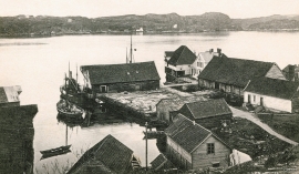
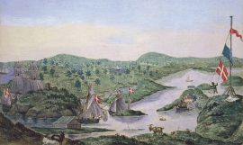
Glesvær- Trading post
Glesvær is one of the oldest trading posts on the West Norwegian coast. In the 1700s and 1800s this was the most important fishing centre on Sotra. The first certain mention of the trading station Glesvær is in 1664. At that time it was the Bergen merchant Hendrich Wessel who owned the place and was in the possession of a trading privilege. Abraham Wessel, who took over in 1688 also obtained Royal Privilege for “Kiøbmandskab med Bønderne alleene at drive” (the only one to be allowed to carry on trade with the farmers).

Golta- Long house
In the years between the wars a major registration of houses and house costumes, house construction methods, fireplaces and forms of housing clusters was started in West Norway – an ambitious mapping of everything that came under the name “Registration of Culture and Geography in West Norway”. One of the places of which material was gathered in 1938 was an old multi-room house at Golta; new and interesting material for the researchers from the Historical Museum, but well known within the local building tradition through several generations.

