- Remove Small landforms filter Small landforms
- Remove Lindås, frå 2020 del av nye Alver kommune. filter Lindås, frå 2020 del av nye Alver kommune.
- Remove Maritime environments filter Maritime environments
- Remove Seabirds filter Seabirds
- Remove Monastery filter Monastery
- Remove Fitjar filter Fitjar
- Remove Ullensvang, frå 2020 del av nye Ullensvang kommune. filter Ullensvang, frå 2020 del av nye Ullensvang kommune.
- Remove Ulvik filter Ulvik
- Remove Cultural landscapes filter Cultural landscapes
- Remove Archaeological findings filter Archaeological findings
- Remove Churches filter Churches

Bjørsvik
The industrial settlement Bjørsvik


Fitjar- the King's farm
In front of Fitjar Church there is a memorial stone, sculpted by Anne Grimdalen and erected in 1961, for the thousand-year memorial of one of the most dramatic events in Norway’s history, the Battle of Fitjar. This was the place where Norway’s king, Håkon the Good, suffered his fatal injury in the fight with Eirik’s sons, probably in the year 961.

Jomfrunuten
Freezing and thawing are processes that influence plant cover, move enormous blocks, stretche long mounds of earth, break open bedrock and create patterns in stone and earth.
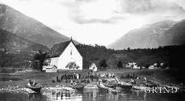
Kinsarvik church
By all accounts the church in Kinsarvik must have been one of the four main churches in the old Horda County. The stone church standing today was restored by cathedral architect Chr. Christie in 1880, and again by Peter Helland-Hansen in 1960-61. At that time an archaeological investigation was undertaken, which has unearthed new knowledge about the church.

Lurekalven
Lurekalven is an unpopulated island of heather moor which is a part of the wilderness belonging to the five farms on Ytre Lygra. Between the two islands there is only a small sound. As late as the 1920s, milking cows were rowed over the sound from Lygra in summer – a form of farming that was adapted to the coastal landscape.

Lygra
The heath landscape on outer Lygra, Utluro and Lurekalven will in future become part of a landscape protection area, to be maintained through traditional activities with year-round outdoor sheep, grazing and burning. The West Norwegian heath country belongs to a large North Atlantic coastal landscape stretching from the Bay of Biscay to the Lofoten islands.

Osa
At the bottom of the Osa fjord there is a cultural landscape marked by great contrasts; the wide terraces and the river delta at the fjord contrast with the steep hillsides in the background, where Norddalen leads up to the mountain. There are two farms here. Osa and Sævartveit – the farm at the river mouth and the hollow by the sea.

Rimsvarden
Rimsvarden lies high and unencumbered, an enormous stone mound on the highest top with a wide view of the Fitjar rural community. With its 30 meters across and almost 4 meters high, this is one of the largest prehistoric burial relics existing in Hordaland.


