- Remove Small landforms filter Small landforms
- Remove Modalen filter Modalen
- Remove Place filter Place
- Remove Sediments filter Sediments
- Remove Boat- and shipyards filter Boat- and shipyards
- Remove Rock carvings filter Rock carvings
- Remove Conservation area filter Conservation area
- Remove Bømlo filter Bømlo
- Remove Lighthouses filter Lighthouses
- Remove Civil servant dwellings and manors filter Civil servant dwellings and manors
- Remove Fusa, frå 2020 ein del av nye Bjørnafjorden kommune filter Fusa, frå 2020 ein del av nye Bjørnafjorden kommune
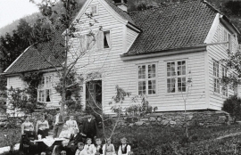
Engevik
Halfway into the Sævareidfjord lies the officer’s farm Engevik. In the beginning of the 1700s the farm was in part estate of the crown and owned by farmers. In 1724 lieutenant-colonel Christian Wilhelm Segelcke settled there and erected a new farm around an imposing main building a little way north of the old farm site.

Stølsheimen
The large mountain area between Modalen, the Voss communities and Sogn is one of the finest mountain pasture areas in West Norway. In older times this area was called Steinslandsheimen, in our times it has acquired the name Stølsheimen. Power development and protection interests have been opposed here. The core area of Stølsheimen has now been protected as a landscape protection area, while some of the oldest mountain farms have been flooded. A register in the 1970s comprised almost 40 mountain farm settlements in the central area of Stølsheimen, belonging to Modalen, Høyanger and Vik municipalities.


Eikelandsosen
"So many and such big potholes as are found at Eikelandsosen, we don't see other places in western Norway, and as beautifully polished as the mountainside is along the river up to Koldal , one would look a long time to see anywhere else. There is much to dazzle a geologist's eyes. If only these features could bring others the same joy!"
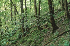
Hopslia
Some of the giant trees in Hopslia north of Holme Fjord are as much as thirty metres high. Elm and ash are the most common, basswood somewhat rarer. Relatively soft bedrock, good growing conditions and enough light, help them to thrive just here.

Skjelbreid
On the east side of Lake Skjelbreidvatnet, clearly visible along the road from Eikelandsosen, we notice a farm on a terrace above a grassy hill. The hill has the form of a broad shield; Skjelbreid (" Broad Shield") is the name of the farm.

Yddal
Yddal is one of the biggest and finest pine forest areas in the county. The rich forest resources provided an important foundation for the settlement of Yddal. Up until about the 1950s, there were three farms here. Where the lumberjacks couldn't get to, the trees grew very big and can be over 300 years old.

Vinnesleira
Bays that are shallow far out into the sea, with fine sand and clay, are rare in Hordaland. Where they are found, the reason is usually that the edge of the glacier made smaller advances or stopovers when it calved back at the end of the last Ice Age. This is what happened at Vinnesleira.

Mostraumen
Until 1743 the people from Modal had to wait for a flood in MOSTRAUMEN before they could draw their boats up the river current, and then row back across Lake Movatnet. But, that year the flood opened a free passageway all the way to Mo. Hordaland had gained a new tidal waterway.

